Unmissable Peak District Walks: Crowd-Pleasers with Quiet Alternatives
Unmissable Peak District Walks: Crowd-Pleasers with Quiet Alternatives
The Peak District packs a lot into a compact map: family-friendly rail-trails, photogenic ridge walks, and quieter moorland classics. This guide pairs the most popular Peak District walks with smart, quieter alternatives so you can match views, terrain, and time to your ability. Most routes are free to access; typical costs are transport, parking, and food, as noted in a Peak District walks guide (see this Peak District walks guide: https://wellness.alibaba.com/outdoor/peak-district-walks-guide). You’ll find three core types below—flat and accessible family trails, rewarding ridges and summits, and remote moorland—for both crowd-pleasers and calmer swaps.
Route grading systems prioritize the ground underfoot—rocky steps, muddy ruts, and steep pitches—over raw mileage to signal real-world effort. A route marked “Moderate” can still include short, steep climbs and rough terrain, even if the total distance is brief. Expect effort to track terrain, not just length (walk ratings guidance: https://www.peaktors.co.uk/essential-info/walk-ratings).
Hiking Manual
At Hiking Manual, we focus on practical, beginner-forward advice: clear route choices, simple navigation with GPS apps, and entry-level gear that builds confidence. We emphasize breathable layers, aluminum trekking poles for stability, and sustainable packs that carry comfortably without excess weight.
Smartphones are reliable trail companions when paired with offline maps and clear route beta. Download maps ahead of time and carry a simple compass as backup. This offline-first setup is the baseline we plan around at Hiking Manual.
How to use this guide
- Step 1: Scan the section for your walk type—family/accessible, ridges/summits, or remote moorland.
- Step 2: Pick either a crowd-pleaser or its quieter alternative.
- Step 3: Use the planning and safety sections to finalize; apps like AllTrails or Komoot let you filter by distance, difficulty, and elevation to match your day.
Decision snapshot:
| Views | Family-friendly | Solitude |
|---|---|---|
| Mam Tor | Monsal Trail, Tissington Trail, Ladybower | Shutlingsloe, quieter Stanage sections, The Roaches (second half) |
Car-free access means reaching trailheads via direct trains or buses—think trains to Edale or Buxton, and bus 257 to Ladybower—cutting parking stress and impact (She Walks in England’s Peak District overview: https://shewalksinengland.com/best-peak-district-walks/).
Family friendly and accessible trails
Looking for flat or gently graded tracks with good surfaces and plenty of turn-around options? The Monsal Trail and Tissington Trail (both former railway lines) plus the Ladybower Reservoir circular deliver accessible Peak District walks with wide paths for mixed-ability groups. Expect weekend crowds on the rail-trails; arrive early or go midweek. Stroller-friendly stretches, regular toilets and parking, and easy public transport (including bus 257 to Ladybower) make these reliable family walks Peak District newcomers love. For family-tested details and inspiration, see Peak District Kids route notes (family-tested route notes: https://peakdistrictkids.co.uk/view-walks/).
Note: Most walks are free; bringing water and snacks reduces café or facility costs.
Monsal Trail
This level, family-friendly railway path threads through tunnels and across graceful viaducts—scenery with zero steep climbs. It’s popular with cyclists and families, so start early or choose a weekday to dial down the bustle. You can join at multiple access points and shorten or extend easily; helmets for kids on bikes and a reflective layer for tunnels are smart. Use AllTrails or Komoot to plan segments, check elevation (it’s flat), and download offline maps; premium tiers run about $35–$40 per year and add offline navigation and safety alerts.
Ladybower Reservoir
For an easy circular walk Peak District newcomers can enjoy, Ladybower’s typical loop is about 5 miles and often completed in under 2 hours with mostly level, well-made paths. Bus 257 from Sheffield drops you near the action for a car-free start. Walk clockwise for morning light on the water and counterclockwise for late-day glow; picnic-friendly spots dot the shoreline with benches and open views.
Tissington Trail
A gentle, accessible walking and cycling route similar to the Monsal Trail, the Tissington follows a broad, near-level railway bed—perfect for mixed-ability groups and pushchairs. Weekends can be busy, so consider early starts or weekdays. Short family segments work well between key car parks; pack water and snacks to avoid mid-route detours.
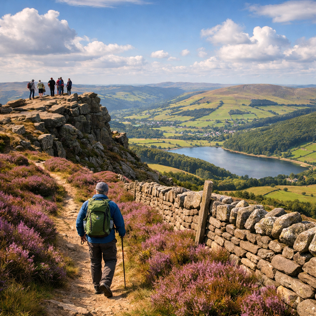
Scenic ridges and summit views
A ridge walk follows an elevated crest with broad views—and exposure to wind and fast-changing weather. Footing can be uneven and slippery when wet. For the best experience on the best Peak District hikes, go at sunrise or on weekdays for Mam Tor and the Bamford–Stanage area, and bring trekking poles for stability on descents.
Mam Tor
The Peak District’s classic: a short climb to sweeping sunrise ridge views. It’s deservedly popular—arrive pre-dawn or midweek to sidestep the rush, and expect windswept exposure. Choose a short loop from the Mam Nick car park or continue the full ridge to Lose Hill for a bigger day. Pack poles and layered, wind-resistant clothing.
Shutlingsloe
A superb quieter swap for Mam Tor, Shutlingsloe offers a compact ascent with big panoramas. The summit stands around 506 m, with roughly 245 m of ascent on a common family route—achievable for motivated kids with regular snack breaks. Wayfinding is straightforward in good weather; save the summit treats for the top.
Kinder Scout
Kinder Scout is a bucket-list plateau of gritstone edges, peat groughs, and moorland skies. From Edale, the classic climb up Grindsbrook Clough leads onto the Kinder Plateau. Navigation on the featureless top demands care in poor visibility—use a GPS app with offline maps and carry a physical compass as backup.
Bamford Edge
A photogenic gritstone edge with famous views across Ladybower. Try a circular linking quieter sections of Stanage (about 6.5 miles, roughly 2 h 45, mostly easy), but expect occasional boggy moorland underfoot between edges. Aim for golden hour and arrive early on weekends to secure parking.
Stanage Edge
Iconic, busy, and manageable with smart route choice. Pick less-trafficked stretches and use open moorland crossings to bypass the busiest viewpoints. Check elevation profiles before committing—on circulars, “mostly easy” still includes uneven rock steps, gusty exposure, and energy-sapping heather trods.
Remote moorland and quiet classics
Moorland is open, often boggy upland terrain with sparse trees and indistinct paths. You’ll find solitude, birdlife, and big skies—but also fast weather shifts and heightened navigational demands. Bring GPS plus compass, waterproof footwear, and set clear turn-back times. Remember, ratings weigh terrain over distance: short miles can still be serious.
The Roaches
A rocky ridge that feels adventurous yet stays family-manageable, with boulders kids love to scramble. Parking fills on blue-sky days, so arrive early. For a calmer experience, walk the second half of the ridge beyond the busiest tors. Pairing The Roaches with a detour to Lud’s Church makes a satisfying full day.
Lud’s Church
A mossy, fairy-tale chasm in the woods, usually quieter than headline photo spots. Expect roughly 3 miles in about 1 hour 20 minutes, rated easy with one short hill—ideal for families. The rock can be perpetually damp; wear grippy footwear.
Chrome Hill
The “Dragon’s Back” delivers spectacular limestone fins with narrow, occasionally exposed footing. Common routes are around 4.5 miles in about 2 hours and feel moderate to challenging depending on confidence. Poles help on steep grass; add wind layers. For a safer family option with similar drama, opt for The Roaches instead.
Planning tips for avoiding crowds
- Go weekdays, at sunrise, or in shoulder seasons; pick alternate trailheads to bypass bottlenecks.
- Pre-filter routes by distance, difficulty, and elevation gain in AllTrails/Komoot; download offline maps before you go.
- Choose car-free access when possible: direct trains to Edale and Buxton, and bus 257 to Ladybower reduce parking pressure and environmental impact.
- Consider guided walks for structure and insights; local options typically run £10–£25 per person.
Beginner safety and navigation essentials
- Do the five checks before you go: distance, difficulty, terrain, transport, elevation— the simple framework we use at Hiking Manual. “Moderate” can still mean steep or rocky.
- Pack water and snacks; download offline maps—maps stored on your phone for GPS navigation without cell service—and carry a basic compass.
- Health context: walking’s benefits generally outweigh crash risks, and places with more walking tend to have lower per-capita traffic death rates (research on nonmotorized transport: https://www.vtpi.org/nmt-tdm.pdf).
Lightweight and sustainable gear picks
Choose breathable layers, lightweight aluminum trekking poles, and an eco-friendly backpack made from recycled fabrics. Lighter kits reduce fatigue on long rail-trails and blustery ridges, while recycled materials dial down impact. Even with GPS, slip a simple baseplate compass into your pack. Hiking Manual’s beginner kit lists focus on these essentials so starting out stays simple and light.
Trekking poles for comfort and stability
Poles reduce knee load on descents and improve balance on rocky, muddy, or boggy terrain—ideal across Stanage, Kinder edges, and Chrome Hill’s steeps. Beginners do well with adjustable aluminum poles.
- Set pole length so elbows are about 90° on level ground.
- Shorten slightly for steep uphills.
- Lengthen slightly for downhills.
Breathable layers and footwear for mixed terrain
Dress for changeable weather: a moisture-wicking base, light fleece, and a windproof shell suit exposed ridges. On feet, pick grippy, waterproof trail shoes or boots for moorland and limestone. Test fit with hiking socks, and add gaiters for the boggy Bamford–Stanage links.
Motivating reads for your Peak District trip
- The Salt Path by Raynor Winn — a resilient, place-rich walk that reframes adversity into momentum.
- The Living Mountain by Nan Shepherd — lucid attention to landscape and weather, perfect for moorland mindset.
- A Walk in the Woods by Bill Bryson — light-hearted persistence and planning lessons for longer ridge days.
Quick comparison list
- Mam Tor: Sunrise ridge views, busy at peak times.
- Kinder Scout (Edale): Wild plateau, navigation needed.
- Monsal Trail: Family friendly, flat former railway.
- Tissington Trail: Accessible cycling/walking route.
- Stanage Edge: Classic gritstone escarpment, photogenic.
- Thor’s Cave: Versatile routes, popular photo spot.
- Chrome Hill: Distinctive skyline ridge, challenging underfoot.
- Ladybower Reservoir: Easy circular, quieter lakeside walking.
- About 5 miles, often under 2 hours on level paths.
Frequently asked questions
What are the most popular walking trails in the Peak District?
Mam Tor, Kinder Scout from Edale, the Monsal and Tissington Trails, Stanage Edge, Thor’s Cave, Chrome Hill, and the Ladybower Reservoir circular are perennial favorites for views, accessibility, and classic gritstone. Hiking Manual pairs these classics with quieter alternatives in this guide.
What are good quiet alternatives to crowded Peak District hikes?
Try Shutlingsloe for summit views with fewer people, connect quieter Bamford–Stanage sections, choose Ladybower for level lakeside paths, walk The Roaches’ second half, or head to Lud’s Church for calm woodland. This Hiking Manual guide flags lower-footfall options alongside each crowd-pleaser.
How can I avoid crowds on popular Peak District walks?
Start at sunrise or on weekdays, aim for shoulder seasons, and use public transport. Use a GPS app’s filters (distance, difficulty, elevation) plus Hiking Manual’s planning tips to pick quieter segments.
Are Peak District walks free?
Yes—access is generally free. Expect incidental costs like transport, parking, and food; Hiking Manual notes typical costs throughout this guide.
Is the Kinder Scout plateau suitable for beginners?
It’s a bucket-list route but demands solid navigation on a featureless top, especially in poor visibility; carry offline maps plus a compass. If you’re new, follow Hiking Manual’s safety checks and go with a guide or experienced friend.
What should I wear for ridge and moorland hikes?
Use breathable base layers, a warm midlayer, and a windproof/rain shell with grippy, waterproof footwear—the simple system we recommend at Hiking Manual. Trekking poles improve stability, and gaiters help on wet moorland.
Can I reach Peak District trails without a car?
Yes. Direct trains reach Edale and Buxton, and local buses such as the 257 serve Ladybower; car-free starts reduce parking stress and impact.
Are guided walks worth it for new hikers?
Often, yes—route expertise, safety coaching, and logistics support help if you’re building skills. Pair them with Hiking Manual’s beginner checklists and route snapshots.