Top Scenic Trail Runs in North America: A Runner’s Shortlist
Top Scenic Trail Runs in North America: A Runner’s Shortlist
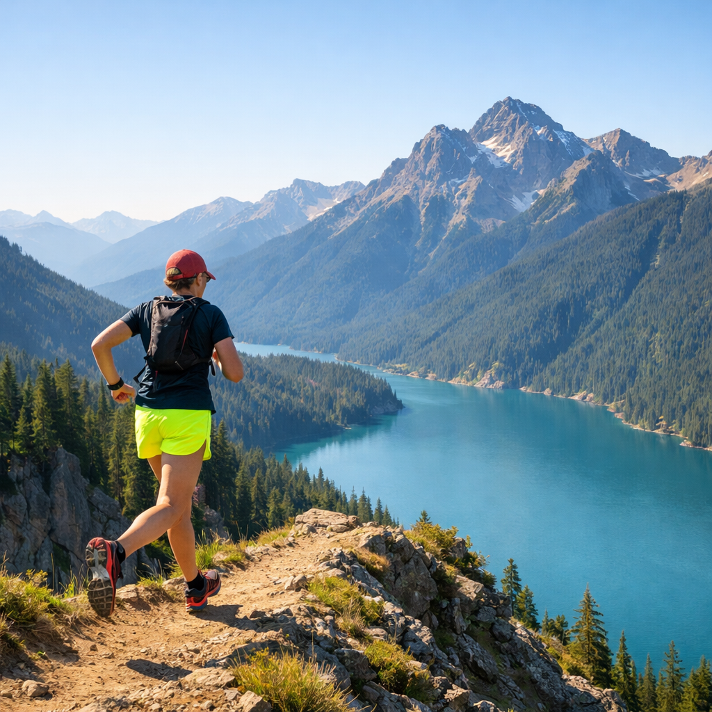
This shortlist zeroes in on North America’s most scenic trail runs that are actually runnable—routes with coastal vistas, waterfall forests, urban ridge lines, and big‑view alpine ridges. Each entry includes quick stats and logistics so you can match scenery to fitness and time. For beginners to intermediates, we emphasize flowy singletrack, approachable elevation, and easy access, while noting a few high‑route challenges for when your legs are ready. Pair these picks with a simple doorstep routine and value‑minded, lightweight gear to turn bucket‑list scenery into your next Saturday.
Hiking Manual
Our philosophy is simple: build consistency at home (a 0.5–1.5 mile doorstep loop plus a weather‑ready indoor fallback), then step onto photogenic trails with confidence. This list spans easy coastal paths, urban ridge views, and high routes with big vertical—ideal for runners logging roughly 6–20 miles per week, a common band for 48% of trail runners, according to the Ultimate Trail Running Stats report from RunRepeat (see Ultimate Trail Running Stats).
For gear, we prefer waterproof, lightweight, value picks that work: day‑run vests for water and phone, plus packs and tents for weekenders. Examples that offer strong value: the Maelstrom 40L (budget travel/weekend hauler), and the TETON Scout 55L (affordable multi‑day carry—great for shuttling gear, not for running).
How to use this shortlist
- Step 1: Choose your scenery. Coast, forest waterfall, glacial hills, urban ridge, or alpine ridge run.
- Step 2: Set distance and elevation. Pick a distance band that fits today, then add climbing that matches your training.
- Step 3: Check access. Confirm parking, seasonality, and any shuttles or fees.
Mini key under every route:
- Distance range
- Elevation gain
- Surface (singletrack/multi‑use)
- Best season
- Logistics
It matches the format we use across Hiking Manual guides for quick comparison.
Most trail runners can reach a trail within an hour—84.6% do so—so we favor easy‑access options where possible (see Ultimate Trail Running Stats).
Selection criteria for scenic trail runs
At Hiking Manual, we prioritized visual payoff, runnable surfaces, and varied effort. Community data shows 84% of trail runners prefer mixed terrain and 47% prefer singletrack, so this list balances views with flow and footing confidence (see Ultimate Trail Running Stats).
“Singletrack is a narrow, mostly one‑runner‑wide dirt path that winds through natural terrain, often with roots, rocks, banked turns, and brief squeezes. It encourages attentive foot placement and flow, keeps crowds down versus wider fire roads, and delivers variety many runners prefer for immersive, quieter miles.”
We also spread elevation and technicality: from mellow Burlington‑area climbs and short peaks to the Adirondack Great Range’s 7,334 feet of ascent—evidence that you can scale effort from approachable to expert within a day’s drive in the Northeast (see Top Rated Runs near Burlington).
Diamond Head Loop
Iconic scenic loop around the Diamond Head Crater near Waikiki, with panoramic ocean views and city‑meets‑crater drama. Surfaces mix paved path, stairs, and dirt; start at sunrise for cooler temps and fewer crowds. Hydrate—heat and humidity spike quickly.
- Distance: 1.6–5.0 mi (summit out‑and‑back or crater‑area loop options)
- Elevation gain: 0–600 ft, depending on summit option
- Surface: Mixed paved/trail; some stairs
- Best season: Year‑round; sunrise and early mornings shine
- Logistics: Park entry/parking fees; limited shade; arrive early (see Most Scenic Running Trails in America)
Montaña de Oro Bluff Trail
A photogenic, nearly flat oceanfront out‑and‑back with cove and cliff views near Los Osos, California. It’s beginner‑friendly and a golden‑hour stunner; watch tides and give wildlife space on narrow sections.
- Distance: ~3.5–4.0 mi out‑and‑back; extend to 6–8 mi via nearby singletrack
- Elevation gain: Minimal (<200 ft)
- Surface: Coastal dirt path with occasional sand
- Best season: Spring/fall for cool temps and wildflowers
- Logistics: Tide awareness, stay off fragile bluff edges (see Most Scenic Running Trails in America)
John Rock Loop
A Pisgah National Forest classic: rolling singletrack to a granite‑capped overlook. Intermediates love the rhythm and payoff; go clockwise for steeper, rockier ascent and gentler descent, or counterclockwise for smoother climbing. After rain, prioritize traction.
- Distance: ~5.0–5.5 mi
- Elevation gain: ~1,000 ft
- Surface: Rooty/rocky forest singletrack
- Best season: Spring–fall; calmer shoulder seasons
- Logistics: Popular on weekends; arrive early (see Most Scenic Running Trails in America)
“Elevation gain is the total vertical climbing accumulated across a route, measured in feet or meters. It’s the strongest predictor of effort on trails because uphill grades slow pace, increase heart rate and muscular demand, and change fueling and pacing needs compared with flat running, especially over sustained climbs.”
Mill Trail to Bingham Falls
Shady, photogenic New England forest running to a gorge and waterfall in Stowe, Vermont—one of the most scenic running trails in the U.S. according to Outside. Expect slick rock near the falls and leaf litter in shoulder seasons; shoes with grip pay off.
- Distance: ~3.0 mi out‑and‑back
- Elevation gain: Modest; short steep pitches near the falls
- Surface: Forest singletrack; wet rock risk
- Best season: Late spring–fall; winter ice possible
- Logistics: Consider nearby add‑ons like Stowe Pinnacle (3.3 mi/1,523’ ascent) to build vert (see Top Rated Runs near Burlington and Most Scenic Running Trails in America)
Island Line Rail Trail
Lake Champlain’s signature waterfront greenway is perfect for recovery miles and sightseeing. It’s flat, open, and breezy; pick an out‑and‑back segment and mind bike/ped etiquette on peak days.
- Distance: Up to 13.0 mi; choose 3–8 mi segments
- Elevation gain: Flat (<150 ft)
- Surface: Paved/gravel multi‑use path
- Best season: Year‑round; wind exposure in colder months
- Logistics: Parking near Waterfront Park; consider causeway and seasonal ferry timing (see Burlington Running Guide)
“A multi‑use path is a paved or well‑compacted corridor designed for walkers, runners, cyclists, and mobility devices. It favors access, continuity, and safety over technical challenge. Expect steady surfaces, gentle grades, clear sightlines, and right‑of‑way etiquette—ideal for beginners, sightseeing, recovery miles, and consistent aerobic training.”
Ice Age Trail
A destination‑worthy long‑trail network across Wisconsin with glacial topography and abundant day‑run segments. Pick bite‑size 5–12 mile sections, plan shuttles for point‑to‑points, and prepare for bugs (summer) and mud (spring).
- Distance: Segmentable; 5–12 mi day runs work well
- Elevation gain: Rolling 200–1,000 ft
- Surface: Singletrack/grass with forest road connectors
- Best season: Spring–fall; mosquitoes peak in midsummer
- Logistics: Trailheads are well distributed; verify parking and shuttles (see 6 U.S. trails worth traveling for)
“Glacial landscapes are terrains sculpted by ancient ice sheets that advanced and retreated, leaving moraines, kettles, eskers, and erratics. The result is rolling relief, interlaced lakes and wetlands, mixed soils, and often softer tread. These features create scenic variety and forgiving footing that many runners appreciate during longer outings.”
Boy Scout Trail
A stark, photogenic Joshua Tree National Park singletrack with boulders, Joshua trees, and open‑desert panoramas. Start early for heat, carry ample water, and bring a navigation backup—there’s no resupply on trail.
- Distance: 4–16 mi (out‑and‑back or shuttle)
- Elevation gain: 500–1,500 ft, depending on turnaround
- Surface: Sandy/rocky desert singletrack; some scrambling spots
- Best season: Late fall–early spring; avoid peak heat
- Logistics: Park entry required; limited shade/water (see 6 U.S. trails worth traveling for)
“Technical terrain refers to surfaces riddled with rocks, roots, sand, steps, or abrupt grades that demand frequent micro‑adjustments in foot placement and balance. It reduces running economy, increases slip‑and‑fall risk, and elevates muscular load, so plan shorter distances, sturdier footwear, deliberate pacing, and extra time on course.”
Mount Hollywood
Griffith Park’s ridge and summit views deliver L.A. skyline drama and Observatory vistas. Expect steeper gains on longer loops; run mornings to dodge heat and clearer air, and use side trails to avoid weekend crowds.
- Distance: 3–9 mi options
- Elevation gain: Up to ~1,290 ft on longer loops
- Surface: Wide dirt roads with soft‑surface connectors
- Best season: Fall–spring; mornings year‑round
- Logistics: Popular area—arrive early; watch for equestrians (see Most Scenic Running Trails in America)
Adirondack Great Range
An expert‑level alpine ridge traverse with sustained steepness and huge views. The classic point‑to‑point is serious—split into sections, learn bail‑out options, and pick good weather windows. Carry multiple navigation layers.
- Distance: 21.0 mi typical traverse; section hikes 6–12 mi
- Elevation gain: 7,334’ total ascent (difficult)
- Surface: Steep, technical singletrack with slabs/roots
- Best season: Summer fair‑weather; shoulder seasons can be icy
- Logistics: Bail‑outs via valley trails; early starts and headlamps required; build capacity on nearby steps like Mount Philo (2.0 mi/546’ ascent) or Northville‑Placid Trail segments (see Top Rated Runs near Burlington)
Match route to fitness and terrain
Use weekly volume, time‑on‑feet, and surface preference to size your day. Many runners fall in the 6–20 mi/week band (48%), and most prefer mixed terrain (84%) with a strong singletrack bias (47%)—choose routes with variety to stay motivated (see Ultimate Trail Running Stats).
- Pacing guide: add 1–2 min/mi on easy trails; 3–5+ min/mi on technical terrain.
| Weekly mileage | Scenic run distance target | Elevation gain target | Surface pick |
|---|---|---|---|
| 6–10 mi/week | 3–5 mi | 300–800 ft | Multi‑use path or gentle singletrack |
| 11–15 mi/week | 4–7 mi | 800–1,500 ft | Mixed singletrack + fire road |
| 16–20 mi/week | 6–10 mi | 1,500–3,000 ft | Mostly singletrack, some technical |
Micro‑routine prep from home
Run a simple two‑week micro‑cycle: three short loops, one longer run, and one mobility session weekly. Keep a light streak by using your indoor fallback during storms or smoke, so readiness doesn’t slip. Daily pack‑check: water, map/phone, light shell, and a small first‑aid item.
Build a 0.5–1.5 mile doorstep loop
- Map a safe loop with one mild incline and, if possible, a short soft‑surface segment; time a “door‑to‑door” test lap.
- Use it for warm‑ups, strides, and midweek aerobic maintenance; add laps (2–4) as fitness grows.
- Add stairs or a small park hill once a week to simulate elevation gain.
Set a weather‑ready indoor loop fallback
- Identify a mall concourse, long hallway, or treadmill block for 10–30 minute sessions; keep an indoor kit pre‑packed.
- Try simple intervals like 5 x 3 minutes easy with 1 minute brisk walk.
- Track rate of perceived exertion and cadence when GPS isn’t reliable indoors.
Value gear for scenic runs
Keep it light, fast‑drying, and budget‑smart. Hiking Manual favors durable, weather‑ready pieces that stretch your dollars without adding bulk. Organize by mission—short scenic runs, destination weekends, and mixed trail‑to‑urban travel—and carry the simple safety basics: map/phone/light.
Backpacks
- Maelstrom 40L: Budget waterproof‑leaning travel/weekend pack. Pros: strong value, lots of pockets, rain cover. Watch‑outs: too big for running; use for transport/basecamp.
- 10–15L running vest/pack: Best for short scenic runs. Look for firm fit, dual flask compatibility, and bounce control.
- TETON Scout 55L: Value multi‑day hauler for camping or gear shuttles; not for running. Durable, roomy, budget‑friendly.
Tents
- Lightweight weekenders (OneTigris/Forceatt/Camppal): Aim for fast pitch (<10 minutes), ~3–5 lb packed weight, and a waterproof rating around 2000–3000 mm.
- Use a footprint and consider seam sealing for storms; vestibules keep wet shoes outside.
- Neutral colors blend in and make pre‑dawn departures easier.
Vests
- Multi‑pocket utility vest: Great for trail‑to‑town transitions; pockets for phone, gels, keys, and transit card.
- Running hydration vest (5–12L): Dual soft flasks, bladder option, pole carry, and quick‑access pockets.
- Safety details: reflective trim and a built‑in whistle pocket.
Seasonal timing and local logistics
- Coasts: spring/fall for cooler air and clear views.
- Deserts: winter and shoulder seasons; start early.
- Alpine: summer fair‑weather windows; beware monsoons and icy shoulders.
- Many scenic routes sit near towns with frequent group runs and easy access—Burlington’s waterfront network is a standout (see Burlington Running Guide).
- Expect crowds at California hotspots—California hosts roughly 11% of U.S. trail events, affecting parking and travel (see Who’s Running Trails and Why It Matters).
Safety, navigation, and group runs
Trails are generally softer and lower‑impact than roads, but footing variability raises fall risk—plan accordingly (see Trail Running 101—Pros & Cons). Anti‑getting‑lost checklist: pre‑plan a route, bring a paper/digital map, carry your phone, and run with a knowledgeable friend. Trail race aid stations often feature simple salty‑sweet staples—fruit, PB&J, M&M’s, soda, electrolytes—for fueling ideas (see Trail Running 101—Pros & Cons). Local series like the Catamount Outdoor Family Center’s weekly trail events in Vermont are great for navigation and seasonal tips (noted in Burlington guides).
Frequently asked questions
What distance and elevation should I choose for a first scenic trail run?
Start with 3–5 miles and 300–800 feet of climbing on gentle grades, keeping the effort conversational; use Hiking Manual’s pacing guide above to size the day.
Do I need permits or reservations for these routes?
Most runs don’t require permits, but parking or park entry often does. Check official park pages or Hiking Manual’s route notes before you go; desert and alpine areas can add seasonal closures or restrictions.
What basic gear should I carry for short scenic runs?
Carry water, a phone with an offline map, a light shell, sun protection, and a small first‑aid item. A compact running vest keeps hands free and improves balance—our default recommendation at Hiking Manual.
How do I find current conditions and avoid getting lost?
Check local park pages or a trusted trail app for closures, download the route, and run with a group when possible. Tell someone your plan and bring a backup map in low‑signal areas; our guides flag common access notes.
What’s a simple way to train for technical terrain before a trip?
Add short hill repeats and strides on your 0.5–1.5 mile doorstep loop, and mix in stairs or rooty sections to practice foot placement. This mirrors Hiking Manual’s keep‑it‑short‑but‑frequent approach.