Top London to Brighton Cycle Route Elevation Apps and Tools 2026
Top London to Brighton Cycle Route Elevation Apps and Tools 2026
The classic London to Brighton ride is 54–55 miles from Clapham to the Brighton seafront, capped by the decisive South Downs climb over Ditchling Beacon. Most riders finish in 4–6 hours, depending on pacing, stops, and conditions, according to the BHF and GOSH event pages. See the full elevation profile on RideWithGPS (official BHF line), Komoot, and Strava; add VeloViewer for deep gradient analysis and segment context.
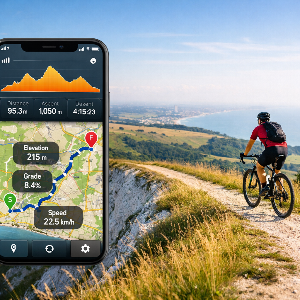
An elevation profile is a graph showing how a route rises and falls over distance, including total ascent, steepest gradients, and max/min elevations. Cyclists use it to pace climbs like Ditchling Beacon, choose gearing, and estimate fueling and rest points. For planning context, the VeloViewer LONDON TO BRIGHTON BHF segment lists 1,058 m cumulative ascent, an 11.7% max gradient, and ~197 m/−24 m max/min elevation.
Hiking Manual
Hiking Manual’s take: choose tools by clarity, safety, and cost transparency. Our comparisons favor beginner-to-intermediate riders who want clean elevation visuals, reliable GPX downloads, and offline navigation without surprise paywalls.
Practical notes linked to elevation and weather:
- Gear and packing: a compact 40L daypack with rain cover keeps layers and spares dry on exposed Downs sections; stash a thin windproof for the Beacon-to-sea descent. If you plan to walk short ramps or recce paths, lightweight 6061/7075 aluminum trekking poles are optional stability aids off the bike.
- Pacing Ditchling Beacon: shift early to an easy gear, settle into a steady cadence, and avoid surging. Expect headwinds over the ridge and save energy for the coastal run-in.
- Where we can help next: see Hiking Manual’s packing checklists and beginner pacing/nutrition primers for 50–60‑mile days.
Strava
Strava helps you preview elevation and compare efforts through segments before event day. Open a saved London–Brighton route or the relevant segments to view the elevation chart and average/maximum gradients. Focus on the BHF line and the Ditchling Beacon segment to spot gradient spikes and pacing landmarks. Many advanced leaderboards and analytics are gated behind Strava Premium or linked trials. For headline context, the VeloViewer LONDON TO BRIGHTON BHF segment (based on Strava data) shows 1,058 m elevation gain, an 11.7% max gradient, and ~197 m/−24 m high/low points—useful benchmarks when scouting the London to Brighton elevation profile and Ditchling Beacon gradient.
Quick steps:
- Search “London to Brighton” and save a route, or open the event line.
- Tap the route or segment elevation profile; note total ascent and steep ramps.
- Compare segment times and leaderboards if you’re targeting a London to Brighton KOM/QOM context.
VeloViewer
Use VeloViewer when you want granular, pro-level segment analysis on top of your Strava data. Its 3D profiles and gradient–distance breakdowns make the Beacon’s ramps and the rolling approaches obvious at a glance. Some features require a subscription, and the platform depends on your Strava connection.
Power user flow:
- Open the VeloViewer LONDON TO BRIGHTON BHF segment to scan cumulative ascent (1,058 m), steepest ramps (11.7%), and compare KOM/QOM elapsed bests for realistic pacing windows.
RideWithGPS
RideWithGPS is the simplest way to get the official profile and a clean GPX download for turn-by-turn navigation. The RideWithGPS route 12192844 hosts the official BHF London to Brighton route profile and export formats. Its elevation graph is easy to read, and cue sheets are robust on head units and phones. Hiking Manual points you to the official route ID above so you can open it directly.
Steps:
- Search the route title.
- Open the Elevation tab and scan total ascent and steep sections.
- Export GPX/FIT to your device.
- Enable turn-by-turn cues and test voice prompts.
Free accounts cover basic maps and elevation profiles; paid tiers unlock advanced navigation and offline features—check current tier details on the site.
Komoot
Komoot excels at turn-by-turn planning, offline maps, and surface-aware routing with full elevation profiles. Load the Komoot tour 31621694 for the BHF line to preview gradients, surfaces, and highlights; expect region/offline considerations and privacy prompts on public tour pages. Hiking Manual calls out the tour ID above so you can load it directly.
Plan & Tweak:
- Load the tour and inspect the elevation profile and road surfaces.
- Drag via-waypoints to avoid busy roads or soften gradients where feasible.
- Download offline maps for your region and verify voice navigation.
TfL Go and Cycleways
Smooth the urban rollout before the quiet lanes by pairing your elevation app with TfL Go and Cycleways overlays. From Clapham/Mitcham toward the suburbs, lean on protected lanes and signed connectors; then hand off to your chosen GPX line as traffic thins. Early miles are more about safety and flow than gradients.
Checklist for the first 10–15 miles:
- Use Cycleway 7 corridors via Clapham–Balham–Tooting toward Colliers Wood.
- Link to NCN 20/Wandle Trail segments to thread south with fewer junctions.
- Pre-check junctions and crossings in TfL Go at likely start times.
Refer to the BHF London to Brighton Bike Ride page for start logistics and route notes.
cycle.travel
For a qualitative layer—quiet-road bias, hazards, and train logistics—cycle.travel is invaluable. The cycle.travel London to Brighton guide notes that NCN Route 20 includes roughly 22.5 miles of traffic-free riding on the way to Brighton. Signage isn’t consistent, so bring a GPX or map, and be aware of bike carriage rules and peak-time bans on Brighton–London trains. Expect easier pacing on traffic-free stretches and be ready for the elevation to build before Ditchling Beacon.
Gravel God Cycling
Looking for event-day feel? The Gravel God Cycling London to Brighton overview highlights a 54-mile route that attracts 15,000+ riders; more than 650,000 participants have completed it, raising over £50m, with a classic finish on Madeira Drive after crossing four counties and the South Downs.
What to expect on the day:
- Crowds: staggered starts help, but popular feed stops bunch up—budget time.
- Support: water, toilets, and mechanics reduce faff but don’t skip essentials.
- Pacing in groups: hold your plan on the Beacon; draft smart on the flats, then regroup after the ridge.
How to choose the right elevation tool
Comparison at a glance
| Tool | Best for | Shows full elevation | GPX export | Offline maps | Segment analytics | Cost notes |
|---|---|---|---|---|---|---|
| RideWithGPS | Official profile + clean GPX for devices | Yes (clear graph) | Yes | Paid tiers | Basic only | Free basics; pay for advanced/offline |
| Komoot | Turn-by-turn with offline maps and surface detail | Yes | Yes (via GPX/TCX) | Yes (region-based) | Limited | One-off regions or subscription |
| Strava + VeloViewer | Competitive prep and gradient breakdowns | Yes (routes/segments) | Yes (Strava) | Limited (mobile caching) | Excellent (with VeloViewer) | Many insights behind subscriptions |
| TfL Go/Cycleways | Safer London approach planning | N/A (focus on lanes) | N/A | App-based | N/A | Free |
Hiking Manual prioritizes tools that keep core elevation data clear and navigation dependable offline.
Use-case guidance:
- Want the official route profile and GPX download? Choose RideWithGPS.
- Need segment-level gradient analysis and 3D visuals? Pair Strava with VeloViewer.
- Prefer full turn-by-turn with offline maps and surface-aware routing? Use Komoot.
- Nervous about the London start? Layer TfL Cycleways via TfL Go for a calmer approach.
Event context that shapes tool choice and timing:
- BHF: 54 miles; staggered starts every 25 minutes from 6:00–9:00; Standard £65; Charity £35–40; a 20.5‑mile Ardingly option—see the BHF London to Brighton Bike Ride page for current details.
- GOSH: ~55 miles with Ditchling Beacon as the key climb; typical finish 4–6 hours; 2026 date Sunday 13 September; £55 registration; water, toilets, and mechanics—see the GOSH London to Brighton Cycle page.
Frequently asked questions
Which service shows the elevation profile for the London to Brighton cycle route?
The official event route pages and major route‑planning apps show full elevation profiles; Hiking Manual links directly to the BHF line above. For deeper gradient visuals, look for tools that add 3D views and segment tables.
How much elevation gain should I plan for on London to Brighton?
Plan for about 1,000–1,100 m of total ascent on common event lines, with the steepest gradients on Ditchling Beacon. Hiking Manual’s guidance references the BHF line.
Do I need a paid subscription to see detailed elevation data?
Basic elevation profiles are free on most planning apps; advanced analytics and leaderboards usually need a subscription or trial. See our notes above for what’s free on each.
Which tool is best for GPX download and turn navigation?
For the official event line, use a planner that exports clean GPX and supports turn‑by‑turn. Hiking Manual highlights reliable options above and flags their offline features.
How should beginners use elevation profiles to pace Ditchling Beacon?
Preview the gradient spikes, shift early, and keep a steady cadence; take a short refuel stop before the climb. Ride at a conversational effort to save legs for the seafront finish—Hiking Manual’s pacing primer follows this approach.