Top Cairngorms National Park Mountain Walks and Hikes for 2026
Top Cairngorms National Park Mountain Walks and Hikes for 2026
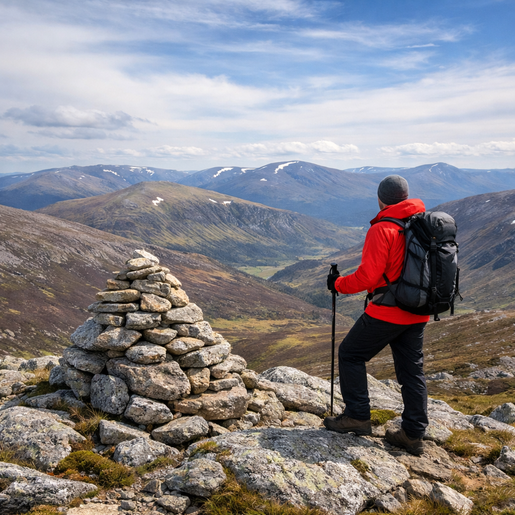
Planning a mountain day in the Cairngorms? You’ve picked a vast, varied corner of the Highlands with routes for every level—from lochside family-friendly hikes to serious Munro bagging on big, exposed plateaux. The Cairngorms is the UK’s largest national park at roughly 4,528 sq km, offering everything from gentle forest paths to steep, remote summits (source: Outdooractive overview of the park). It also holds over 50 Munros and includes Ben Macdui, the UK’s second-highest peak, making it a prime destination for mountain walks in Scotland and guided walking holidays (source: Cicerone’s Walking in the Cairngorms). Below, you’ll find Hiking Manual’s 2026-ready picks: safe, achievable options for beginners, confidence-building summits, and classic big days—plus lightweight kit tips to keep things simple.
Hiking Manual
Hiking Manual’s promise: beginner-first, evidence-informed guidance that trims faff. Expect low-friction route picks, clear risk notes, and lightweight, budget-friendly gear ideas that prioritize compact packability, weather resistance, ease of setup, and unisex fits—useful across both outdoor days and everyday life.
Who this guide is for:
- First-time visitors to the Cairngorms
- Families seeking family-friendly hikes
- Casual hikers aiming for the best mountain walks in Cairngorms National Park
- New Munro baggers wanting safe, confidence-building options
Brand voice note: We keep it straightforward, neutral, and utility-first. Expect plain-English route guidance, honest timings, and safety cues you can act on. Where specs appear, we translate them into simple benefits. If a plan sounds marginal for the day, we’ll nudge you to an easier win.
How to choose a Cairngorms route
Match your route to time, skills, and weather. Use this quick filter:
- Time available
- 2–4 hours: sheltered forest/loch circuits and low hills
- 4–7 hours: single-summit Munros or high corrie rims
- 8–12+ hours: link-ups and plateau traverses
- Skills required
- Waymarked forest paths: suitable for beginners
- High plateau navigation: map-and-compass proficiency essential; exposure likely
- Weather window and season
- Winter/high tops require specific skills and kit (see Safety)
Definition: Munro — A Munro is a Scottish mountain over 3,000 ft (914.4 m). Many Cairngorms Munros sit on broad, exposed plateaux where navigation and weather awareness are critical.
Data to frame expectations:
- The park’s routes genuinely span all abilities, from gentle loch loops to steep summits (Outdooractive’s Cairngorms hiking overview).
- Komoot’s guide lists 2 easy, 8 moderate, and 6 difficult mountain hikes in the Cairngorms, reflecting balanced options for most walkers (Komoot’s Cairngorms mountain hikes guide).
If unsure, step down a category—Hiking Manual leans conservative on time and risk.
Quick comparison (indicative stats)
| Route | Distance | Ascent | Time | Difficulty | Key Risks | Best For |
|---|---|---|---|---|---|---|
| Ben Macdui (from Cairngorm ski area) | 17–19 km | 900–1,000 m | 6–9 h | Hard | Whiteouts, exposure | Experienced hikers seeking a high plateau |
| Cairn Toul–Braeriach traverse | ~36 km | 1,800–2,100 m | 2 days | Very hard | Remoteness, cornices | Fit navigators, backpack overnights |
| Lochnagar (via Loch Muick) | 17–19 km | 1,000–1,100 m | 6–8 h | Hard | Cliffs, fog | Classic Munro day with drama |
| Meall a’ Bhuachaille loop | ~9.0 km | ~470 m | 3–4 h | Moderate | Wind on summit | Confident beginners, families (variants) |
| Loch an Eilein & Rothiemurchus | 5–7 km | <100 m | 2–3 h | Easy | Busy car parks | Families, mixed-ability groups |
| Carn Liath–Càrn nan Gabhar (Beinn a’ Ghlo) | 22.4 km | 1,160 m | 8–10+ h | Hard | Broad tops, commitment | Fit hikers chasing quieter Munros |
| Creag Bheag (Kingussie) | 4–6 km | ~200–250 m | 1–2 h | Easy | Wind exposure | “Micro-session” sunset/sunrise |
| Ben Vrackie (Pitlochry) | ~10 km | ~700 m | 3.5–5 h | Moderate | Steep final ascent | Step-up day with easy access |
| Meall Chuaich (A9) | 10–12 km | ~600 m | 3.5–5 h | Moderate | Wind on upper slopes | First Munro attempt in good weather |
| Sgòr Gaoith (from Glen Feshie) | 15–17 km | ~900 m | 5–7 h | Hard | Cornices, strong winds | Big views with a defined line |
What to pack for a safe, lightweight day
Aim for compact, weatherproof, and simple to use. This keeps your carry light while covering mountain essentials. Use the quick checklist and internal links to keep decisions simple.
- 10–25 L daypack (packable frame or light frame sheet)
- Paper map + compass and a phone with offline mapping
- Layering: breathable base, warm mid, windproof/waterproof shell
- Hat, gloves (carry a spare pair), and buff/neck gaiter
- Food you’ll actually eat + 1.5–2 L water (add a filter if needed)
- Headlamp with fresh batteries
- Small first-aid kit + blister care
- Emergency shelter (lightweight bivy or bothy bag)
- Seasonal adds: microspikes/crampons and ice axe (winter/high tops); midge repellent and a head net in summer—July/August can be buggy at lower levels (guidance summarized in Cicerone’s Walking in the Cairngorms)
Quick checklist
| Item | Why it matters | Packability tip |
|---|---|---|
| 10–25 L daypack | Right size for layers + safety kit | Pick a light, unisex fit with simple harness; see our beginner daypacks guide |
| Waterproof shell | Blocks wind/rain on exposed plateaux | Favor a compact, 2.5–3L laminate with easy hood adjusters |
| Insulating midlayer | Warmth when you stop or in wind | Synthetic puffy or fleece; stuffs into its own pocket |
| Map + compass + phone GPS | Redundancy if fog/whiteout | Keep the compass accessible; see our compass picks |
| Headlamp | Late finishes, emergencies | Choose 70–200 g models with lockout mode |
| Emergency shelter | Protection while waiting for help | 2–4 person bothy bags pack small for groups |
| Traction (seasonal) | Frozen paths, neve on tops | Microspikes for paths; crampons + axe for winter routes |
Internal links: Hiking Manual guides for beginner daypacks, beginner hiking shoes, and reliable compasses
- Our beginner daypacks: https://www.hikingmanual.com/best-hiking-backpacks-for-beginners-top-picks-for-outdoor-adventures
- Beginner hiking shoes: https://www.hikingmanual.com/best-hiking-shoes-for-beginners-top-picks-for-comfortable-adventures
- Reliable compasses: https://www.hikingmanual.com/best-hiking-compasses-for-survival-top-picks-for-outdoor-adventures
1. Ben Macdui
Ben Macdui is a flagship Cairngorm plateau Munro—huge views, but serious exposure. Most walkers start from the Cairngorm ski centre; allow 6–9 hours for the round. In poor visibility, featureless terrain makes navigation challenging and the weather can change fast (hazards highlighted in Path & Pine’s Cairngorms hiking guide). Carry map/compass; in winter, add axe/crampons.
- Pros: Second-highest summit in the UK; classic plateau experience
- Cons: Broad, exposed tops; whiteouts and cornices possible
2. Cairn Toul to Braeriach traverse
A remote, high-commitment skyline traversing several Munros—often planned as a 2‑day trip. The line is roughly 22.25 miles and commonly split with bothy options en route, many maintained by the MBA (Much Better Adventures’ Cairngorms hikes guide). Expect technical navigation, corrie-edge exposure, and limited rescue access.
- Skills: Confident navigation, river/corrie hazard awareness
- Pros: Wild feel, outstanding summits
- Cons: Long commitment; weather and wind amplify risk—pack an emergency shelter even if you plan to use bothies
3. Lochnagar
A dramatic Munro day commonly accessed from the Balmoral Estate via Loch Muick. The summit stands at 1,155 m with a famed corrie and cliff architecture; the Loch Muick circular is roughly 8 miles and a good taster loop for mixed groups before a full summit push (as outlined by Much Better Adventures). In clag, stick to established paths and watch for cliff edges.
- Highlights: Granite cliffs, estate paths, potential red deer and raptor sightings
- Effort: 6–8 hours for the full Munro round; steady, sustained ascent
4. Meall a’ Bhuachaille loop via An Lochan Uaine
A confidence-building hill day above Glenmore Forest with clear trails and a rewarding summit. The An Lochan Uaine – Meall a’ Bhuachaille loop is about 9.05 km with ~470 m ascent; families can opt for the Green Lochan via Ryvoan Pass variant at ~5.5 km and ~292 m ascent (route options summarized by The Wave to the Woods).
- Start: Glenmore
- Highlights: Ryvoan Pass, the vivid “Green Loch,” panoramic summit
- Time: 3–4 hours (loop); 1.5–2.5 hours (Green Lochan variant)
5. Loch an Eilein and Rothiemurchus circuit
A low-level, sheltered loop through ancient pinewoods with a photogenic 13th-century island castle. It’s our top pick for families and mixed-ability groups near Aviemore, with frequent wildlife sightings and good waymarking. Plan for 2–3 hours and arrive early in peak season to avoid busy car parks.
- Pros: Gentle gradients, waymarked, year-round appeal
- Cons: Popular on weekends and holidays
6. Carn Liath to Càrn nan Gabhar ridge
A big, quieter Munro day along the Beinn a’ Ghlo ridge. The standard loop from Loch Moraig is 22.4 km with 1,160 m ascent; expect 8–10+ hours. Navigation across broad tops can be tricky in poor visibility—pace your day and watch your turnaround time.
- Pros: Expansive views, satisfying ridge line
- Cons: Long commitment and wind exposure
7. Creag Bheag
An accessible, short summit from Kingussie that delivers outsized views—perfect for a golden-hour micro-session or a recovery day.
- Duration: 1–2 hours; good paths; family-suitable with supervision
- Pros: Fast payoff; easy logistics
- Cons: Limited shelter in wind or showers
8. Ben Vrackie
A well-trodden single-summit day from Pitlochry with straightforward access and a steep but manageable final pull. It’s a great step-up objective for improving beginners and a southern approach option for visitors based beyond the park’s core.
- Time: 3.5–5 hours; best in clear weather for views over Tummel and beyond
- Tip: Poles help on the descent
9. Meall Chuaich
A straightforward Munro often tipped as a first-timer’s target in settled weather. Clear estate tracks and a direct line make the navigation simple, but expect exposure on the upper slopes. Parking and access are convenient from the A9 corridor.
- Distance/time: 10–12 km; 3.5–5 hours; ~600 m ascent
- Best in: Spring through autumn, under fair forecasts
10. Sgòr Gaoith
A dramatic, edge-of-plateau summit with cliff-top views over Loch Eanaich. The route from Glen Feshie is well-trodden to the plateau, then exposed near the rim—beware cornices and gusts. Glen Feshie is also a beacon of Caledonian pine forest regeneration and wildlife recovery (insight from Highland Guiding’s Cairngorms walking notes).
- Time: 5–7 hours; ~15–17 km; ~900 m ascent
- Tip: Keep well back from edges in snow or strong winds
11. Northern Corries rim
A classic corrie-rim circuit above Coire an t‑Sneachda and Coire an Lochain, close to the Cairngorm ski area. Views are airy and immediate; in poor visibility, the rim’s navigation difficulty rises fast and cliff/cornice hazards are real (noted in Path & Pine’s guide to Cairngorms walks).
- Time: 4–6 hours; start at the ski centre
- Winter: Treat as a mountaineering day—ice axe, crampons, and skills required
12. Braeriach via Chalamain Gap
A top-tier summit day for prepared hikers. The Chalamain Gap’s boulders demand care, and the long pull to the plateau means sustained exposure. Build in turn-back points and watch time closely; expect 8–11 hours.
- Pros: One of Scotland’s highest summits, huge vistas
- Cons: Long day, complex terrain, boulder hazards
13. Glen Feshie viewpoints
Choose from several moderate, scenic options that trace the restored glen and pinewoods—ideal for photography, wildlife spotting, and mixed-ability groups. Expect 2–4 hour returns to balcony viewpoints with low-to-moderate ascent and reliably good paths.
- Best light: Early and late day for side-lit ridges
- Family note: Sheltered woodland sections suit younger walkers
14. Lairig Ghru day out and variants
Definition: Lairig Ghru — A high mountain pass crossing the central Cairngorms. It links Speyside and Deeside via a glacial trench with boulder fields, high winds, and limited shelter—serious conditions in poor weather.
A full traverse is a committing long day best in long daylight months; logistics for transport/return are key. Strong hikers can sample out-and-back sections from the Rothiemurchus side for a taste of the pass without committing to the whole crossing. Plateau navigation and weather remain the crux.
15. Uath Lochans and Farleitter Crag
A short, scenic loop through forest and lochans culminating at Farleitter Crag—top pick for families, gentle days, or a recovery leg-stretcher.
- Time: 1.5–2.5 hours; low ascent; waymarked sections
- Pros: Sheltered, quiet, photogenic
- Cons: Midges can be active in summer at low levels—pack repellent and a head net
Planning tips and seasonality
Use the seasonal matrix to calibrate plans to daylight, weather, and group energy.
- May–June often deliver the best mix of daylight, firming paths, and fewer midges; July–August can be buggy at lower levels. Snow commonly blankets high tops from December into April, with winter conditions persisting in spring (seasonality guidance from Cicerone’s Walking in the Cairngorms).
- As a pacing benchmark, guided walking holidays in the area often feature 9–16 km days with 200–600 m ascent—use this to gauge your group’s comfort range (WalkingWomen’s Cairngorms 2026 overview).
Seasonal matrix
| Season | Daylight | Snow risk (tops) | Midges | Gear notes | Best route types |
|---|---|---|---|---|---|
| Spring (Mar–May) | Increasing | Likely above 900 m | Low–moderate | Warm layers; spikes/axe may still be needed | Low-level forests; select Munros in settled spells |
| Summer (Jun–Aug) | Longest | Unlikely, but patches linger | Higher at low levels | Light shells; midge repellent/head net | Family-friendly loops; single-summit Munros |
| Autumn (Sep–Oct) | Shortening | Early snow possible | Declining | Warmer layers; headlamp essential | Forest colors; weather windows for classic tops |
| Winter (Nov–Feb) | Short | High likelihood | None (cold) | Axe/crampons; goggles; spare gloves; bothy bag | Low-level loops in poor weather; winter skills for high routes |
Safety notes for winter and shoulder seasons
On the Cairngorm plateaux, weather can swing fast—fog, wind, rime ice, and whiteouts can arrive in minutes. Conservative decision-making is the win.
- Winter requires alpine kit (crampons and ice axe) plus advanced navigation skills; treat corniced rims with extreme caution (consistent with Cicerone’s winter guidance).
- Expect remote rescue response times; carry an emergency shelter and spare layers.
- Safety flow:
- Check MWIS/Met Office forecasts and avalanche reports (SAIS) if applicable.
- Set a strict turnaround time and stick to it.
- Pack winter-capable layers, spare gloves, and an emergency shelter.
- Confirm navigation redundancy: paper map and compass plus GPS, with power backup.
- Bothies/wild camping: Wild camping is permitted when done responsibly, and bothies exist in parts of the range; treat them as emergency or planned overnight options, not guarantees (as noted by Much Better Adventures).
Frequently asked questions
What is the best time of year to hike the Cairngorms?
May–September offers the longest daylight and best access; May–June often has fewer midges, but high tops can hold spring snow—check forecasts. See Hiking Manual’s seasonal matrix above.
Which Cairngorms hikes are best for beginners?
Start with Loch an Eilein & Rothiemurchus, Uath Lochans and Farleitter Crag, or Creag Bheag; in good weather, confident beginners can try Meall a’ Bhuachaille via An Lochan Uaine. Use Hiking Manual’s quick comparison table to gauge time and risk.
Do I need special navigation skills on the plateau?
Yes—the high plateaux are broad and exposed, and mist or snow can erase features; carry a map and compass, know how to use them, and keep GPS as backup (see Hiking Manual’s reliable compasses guide).
Are there bothies or shelters on these routes?
Some longer routes pass near bothies and simple shelters, but treat them as emergency or planned overnight options, not guaranteed comforts; always carry your own shelter and warm layers.
How do I manage weather, midges and rapid conditions changes?
Check forecasts, pack waterproof/windproof layers, and set a turnaround time; in summer carry repellent and a head net, and in winter bring crampons/axe and adjust quickly if conditions change. Use Hiking Manual’s quick checklist to keep it simple.