Struggling to Find Peak District Panoramic Hikes? Start Here
Struggling to Find Peak District Panoramic Hikes? Start Here
Overwhelmed by choice? You’re not alone. With hundreds of mapped options, it’s easy to stall—AllTrails lists roughly 939 trails in the Peak District showcasing scenic peaks and vistas, from gentle paths to big moorland days (see the AllTrails overview of the Peak District). A panoramic hike is a walking route with sustained, wide-angle views across valleys, ridges, or moorland plateaus. These trails typically gain elevation to reach open terrain—edges, summits, or viewpoints—where you can see distant skylines, reservoirs, and rolling dales on clear days. This Hiking Manual guide narrows the field to three proven route types—accessible trails, classic ridges/edges, and remote moorland—so you can match fitness, weather, and appetite for exposure to one starter route today.
Set your objective for views and effort
Decide first: Do you want easy scenic paths, classic skyline ridges, or big wild moorland views? Matching views-to-effort helps prevent overcommitting and abandoning hikes.
- Easy scenic: Monsal Trail, Dovedale Circular—low ascent, valley panoramas, and cafe stops noted in the Peak District walks guide.
- Classic panoramic ridge: Mam Tor & the Great Ridge, Lose Hill, Stanage Edge—signature ridge walks with the best views in the Peak District and approachable terrain.
- Remote moorland: Kinder Scout, Bleaklow, Pennine Way sections—vast horizons on moorland walks with stronger navigation needs.
Choose the right route type for panoramas
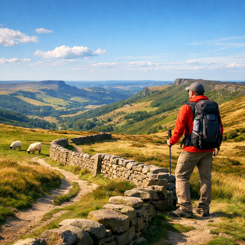
An edge walk follows a gritstone escarpment or ridgeline with steep drops on one side and open moorland on the other. These routes are windy and exposed but deliver continuous horizon views and photogenic gritstone features along relatively straightforward navigation.
| Route type | Effort (distance/ascent) | Exposure (wind/drops) | Navigation (wayfinding) |
|---|---|---|---|
| Accessible valleys/trails | Low–moderate; mostly level | Low; sheltered in valleys | Easy; clear paths and signage |
| Classic ridges and edges | Moderate; short steep pulls | Moderate–high; very windy tops | Moderate; linear, obvious edges/ridges |
| Remote moorland plateaus | Moderate–high; boggy sections | High; very exposed | Hard; few landmarks, relies on map/compass |
Accessible valley and trail options
If you want simple surfaces, low ascent, and regular facilities, head for Monsal, Tissington, and Dovedale—paved or compacted paths and family‑friendly gradients make them ideal first panoramic hikes (as outlined in the Peak District walks guide). The Peak District Ranger team also publishes 10 family routes—six shorter “Explorer” options under three miles and four “Adventurer” routes around three miles, many starting near car parks and public transport (see the Peak District Ranger walking guides).
Classic ridges and edges
For the best views‑for‑effort, pick a ridge or edge on a clear, calm day. Mam Tor & the Great Ridge delivers a full panorama day (~13.2 km, ~473 m ascent) with gusty exposure and broad skylines over Edale and the High Peak (route details in the Best Peak District routes by Live For The Outdoors). Lose Hill (476 m) caps the ridge with sweeping valley views, while Stanage Edge offers big‑sky gritstone drama—expect wind and airy drops. For variety, try the Four Edges Walk (~16 km, ~305 m gain) to string together multiple viewpoints.
Remote moorland panoramas
A moorland plateau is a broad, high-elevation expanse of heather, peat, and gritstone with few landmarks. Paths can be faint, boggy, and confusing in poor visibility, making map-and-compass skills important for safe travel across long, open terrain. Kinder Scout’s plateau rises above 2,000 ft and, in clear weather, dishes out broad, 360‑degree horizons (see Robbie Roams’ Peak District picks). Bleaklow via Wildboar Clough (~20.2 km, ~520 m ascent) is a hard, full‑day with serious navigation—reserve for strong fitness and stable weather (see the Live For The Outdoors routes).
Pick a named starter route
Choose one now and save it offline before you go:
- Monsal Trail or Dovedale Circular (easy): 5–10 km, minimal ascent; valley panoramas, bridges, stepping stones; perfect first Peak District panoramic hikes with cafes and simple logistics.
- Mam Tor & the Great Ridge (moderate): ~13.2 km, ~473 m ascent; ridge‑line views, ancient hillfort remains, optional spur to Lose Hill for the widest vistas.
- Kinder Scout or Bleaklow (challenging): Kinder plateau panoramas on clear days; Bleaklow via Wildboar Clough (~20.2 km, 520 m) is a serious navigation test; consider Win Hill (~8.4 km, 415 m) as a shorter training step with Ladybower views.
Before setting out, skim a recent trip report and download your route for offline use.
Monsal Trail or Dovedale Circular
Expect compacted surfaces, low ascent, and plenty of facilities—ideal for families and first timers (noted in the Peak District walks guide). Thorpe Cloud and the Dovedale stepping stones are short, photogenic detours; National Trust car parks may charge for toilets. For a classic panorama shot, photograph the valley from Monsal Head (see Robbie Roams’ Peak District picks).
Mam Tor and the Great Ridge
Plan for wind: ~13.2 km and ~473 m ascent demand layers and a steady pace (route card in Live For The Outdoors). Mam Tor (~517 m) crowns the ridge with the remains of an Iron Age hillfort for added interest, and a short spur to Lose Hill widens the Edale and Hope valley perspectives (see the same route guide).
Kinder Scout or Bleaklow
Kinder’s vast plateau can feel alpine on a blue‑sky day, but it punishes in clag—treat it as a progression from ridges (context in Robbie Roams’ Peak District picks). Bleaklow via Wildboar Clough (~20.2 km, 520 m) is a hard, remote outing with real nav; build toward it via Win Hill (~8.4 km, 415 m) and other edge loops (see Live For The Outdoors).
Plan with reliable maps and apps
Hiking Manual recommends carrying paper Ordnance Survey maps as primary/backup and pairing them with one offline app for previews and live positioning. Free app tiers are enough for most hikes, with paid tiers adding extras (noted in the Peak District walks guide).
OS Explorer OL1 and OL24
Use OS Explorer OL1 and OL24 to cover the Peak District National Park’s popular areas and moors (see Navigating in the Peak District). “An OS Explorer map is a 1:25,000-scale Ordnance Survey map showing detailed rights of way, contours, field boundaries, and access land—ideal for planning gradients, navigating paths and open access, and identifying crags, streams, and trig points.” Mark start points, bail‑outs, and nearby train/bus stops on paper.
Saving offline routes in Komoot or OS Maps
Plan or import routes in Komoot or OS Maps, download offline tiles, and test airplane mode before leaving signal. Free versions suffice for many routes; premium options add features like live weather and multi‑day planning—AllTrails premium is roughly $35/year and Komoot plans up to about $40/year (as summarized in the Peak District walks guide). Komoot’s turn‑by‑turn with offline reliability works well on UK hikes.
Check weather, daylight, and transport
Align your route with a stable forecast and set a turnaround time that preserves daylight. On ridges and edges, aim to finish 60–90 minutes before sunset to avoid cold, windy descents.
Met Office and mountain forecasts
Always check a mountain‑area forecast and carry suitable clothing and navigation tools; in winter conditions, ice axes and crampons may be essential—and you need the skills to use them (reinforced by the Live For The Outdoors safety notes). Expect stronger winds on edges and pack layers accordingly.
Parking and public transport to trailheads
Managed car parks typically cost £3–£6, while limited roadside parking may be free; a return train fare Manchester–Edale is around £10, giving car‑free access to ridges and moorland (pricing context from the Peak District walks guide). Several family walks start near car parks and are reachable by train or bus (see the Ranger walking guides).
Pack essentials for exposed viewpoints
Keep weight low but be ready for wind. Focus on footwear, layers, navigation, and simple safety backups—budget‑friendly options can work well when chosen carefully.
Footwear, layers, and budget-friendly basics
- Footwear: Invest in quality waterproof hiking boots (~£80+) to reduce injury risk and last years (noted in the Peak District walks guide).
- Layers: Lightweight waterproof shell, warm mid‑layer (budget down in colder months), hat and gloves.
- Hydration/food: Bring water and snacks—don’t rely on pubs/cafes.
- Useful budget kit: Trekology Trek‑Z or TrailBuddy poles; entry‑level packs (Loowoko, SKYSPER, Bseash); ultralight tents (Clostnature) and compact stoves (Fire‑Maple Fixed Star 1, AOTU) for longer days or simple overnights.
Safety, navigation, and contingency
Carry OS Explorer OL1/OL24, compass, headtorch, first‑aid, spare battery, emergency layer, and whistle. A turnaround time is a predetermined latest time to stop progressing toward your objective and start heading back. It protects daylight margins, avoids fatigue on complex ground, and keeps you from pushing on when weather or visibility worsens. Identify bail‑out paths off ridges and edges before you start.
Navigate confidently on the day
Confirm position at obvious landmarks and junctions, and keep your phone in airplane mode to conserve battery. Use dead‑reckoning between known points, and revert to paper maps whenever the path or phone signal deteriorates.
Landmarks, timing, and turnarounds
Use edges, trig points, valleys, and walls as handrails; verify progress every 15–30 minutes. Add a 10–20% time buffer for photo stops on panoramic routes. If you’re behind schedule by halfway, enforce your turnaround time.
Low-visibility decisions on ridges and moors
In mist or squalls, slow down, switch to map‑and‑compass, and consider turning back—standard best practice for UK hills (echoed in the Peak District walks guide). Remote moorland demands strong navigation and fitness; don’t press into featureless terrain if uncertain.
When to go for the best views
Pick high‑pressure, clear days for far‑reaching horizons, and check wind speeds on edges. Two flexible plans: a sunrise ridge (Mam Tor/Stanage) for golden light and quiet trails, or a late‑afternoon valley walk (Monsal/Dovedale) with softer light and easy exits.
Sunrise, clear days, and crowd avoidance
Start at sunrise or midweek on Mam Tor or Stanage to beat crowds; arrive early to secure parking (typical fees £3–£6 per the Peak District walks guide). Bring a headtorch for pre‑dawn approaches on ridges.
Family and photography considerations
For families, use Ranger “Explorer” routes and short scenic options like the Dovedale stepping stones—several begin near parking and public transport (see the Ranger walking guides and Robbie Roams’ tips). Photographers should prioritise the Great Ridge and Stanage at golden hour; pack windproof layers and a lens cloth for gritstone edges.
Frequently asked questions
What are the best first panoramic hikes if I’m new to the Peaks?
Start with the Monsal Trail or Dovedale Circular for easy valley views, then step up to Mam Tor & the Great Ridge on a clear, calm day. That’s the progression we use at Hiking Manual.
How do I avoid crowds at Mam Tor and Stanage Edge?
Arrive for sunrise or midweek, park early, and use lesser‑known access paths; keep moving beyond the busiest viewpoints.
Do I need paper maps if I use a navigation app?
Yes—carry OS Explorer OL1/OL24 as backup; at Hiking Manual we pair a paper map with one offline app.
What should I pack for windy ridge and edge walks?
Sturdy waterproof boots, a lightweight shell, warm mid‑layer, hat/gloves, snacks, water, headtorch, paper map/compass, and a charged phone with offline maps. That’s our baseline kit at Hiking Manual.
How can I get to panoramic hikes without a car?
Take the train to Edale for ridge and moorland access or use buses serving family‑friendly trails; start and finish near stations or major car parks.