Skip the Crowds: Gentle Lakeside Hikes Across the Peak District
Skip the Crowds: Gentle Lakeside Hikes Across the Peak District
Looking for quiet lakeside walks in the Peak District? This guide steers you to peaceful waters, smart timings, and beginner-friendly loops—plus offline navigation so you can relax even when signal drops. At Hiking Manual, we focus on low-stress routes and simple planning so beginners and families can enjoy big views without the squeeze. Crowding matters here: National Trust counters estimate Mam Tor sees close to a million ascents annually, erosion has required helicopter-delivered path repairs, and mountain rescue recorded 77 callouts in 2024 alone (a reminder to choose calm days and prepared plans) according to BBC reporting on Peak District rescues. For a stress-free day, pick lesser‑known reservoirs, arrive early on weekdays, and carry offline maps.
Why quiet lakeside walks matter
Serene waterside paths are kinder to beginners and to the landscape. Moving away from honeypots helps reduce parking chaos, path wear, noise, and avoidable rescue incidents. Local guidance also notes police ticketing around busy sites such as Ladybower; plan legal parking and be willing to pivot to a quieter alternative, as highlighted in Peak District crowd-avoidance advice from UKHillwalking.
Honeypot area (definition): A honeypot is a heavily promoted beauty spot that attracts disproportionate visitor numbers to a small area. The result is concentrated pressure: overfull car parks, verge blocking, noise, and accelerated path erosion. In the Peak District, authorities actively enforce parking rules around popular reservoirs and viewpoints.
Choose quieter Peak District walks beside reservoirs and shaded river dales to enjoy gentle hikes that still deliver big scenery—peaceful lakes, family-friendly routes, and easy shoreline miles without the squeeze.
How to plan a crowd-free lakeside day
Use this simple, repeatable Hiking Manual flow:
- Choose a lesser‑promoted reservoir or river dale (e.g., Winscar over Langsett; Chee Dale over Dovedale).
- Pick off-peak timing (weekday mornings or late afternoons). Even popular areas can feel calm outside peak hours.
- Set a backup destination 10–20 minutes away. If your first car park is full, go elsewhere rather than circling or risking a ticket.
When practical, go by train or bus to valley hubs, then walk from there. Ethical local events model this well by timing starts to public transport and minimizing congestion, as outlined by the Peak District Challenge’s environmental practices.
Leave No Trace (definition): A simple outdoor ethic: plan ahead; pack out all litter; stay on durable surfaces to protect vegetation; respect wildlife and other users; and skip fires and disposable BBQs. In the Peak District, BBQs are a high summer fire risk, and land managers regularly warn against them.
Hiking Manual route-planning basics
For a calm day by water, keep it simple:
- Confirm distance and elevation: aim for loops under 10 km with less than 200 m of ascent for a gentle pace.
- Download offline maps and a GPX route in your preferred app (Komoot, OsmAnd) for the Peak District route you’ll walk.
- Save car park pins and toilets; add a clear bail‑out point for cutting a loop short.
- Note shared-use sections and expect cyclists; keep left and be audible when overtaking.
- Add Plan B options reachable within 20 minutes if your first choice is busy or closed.
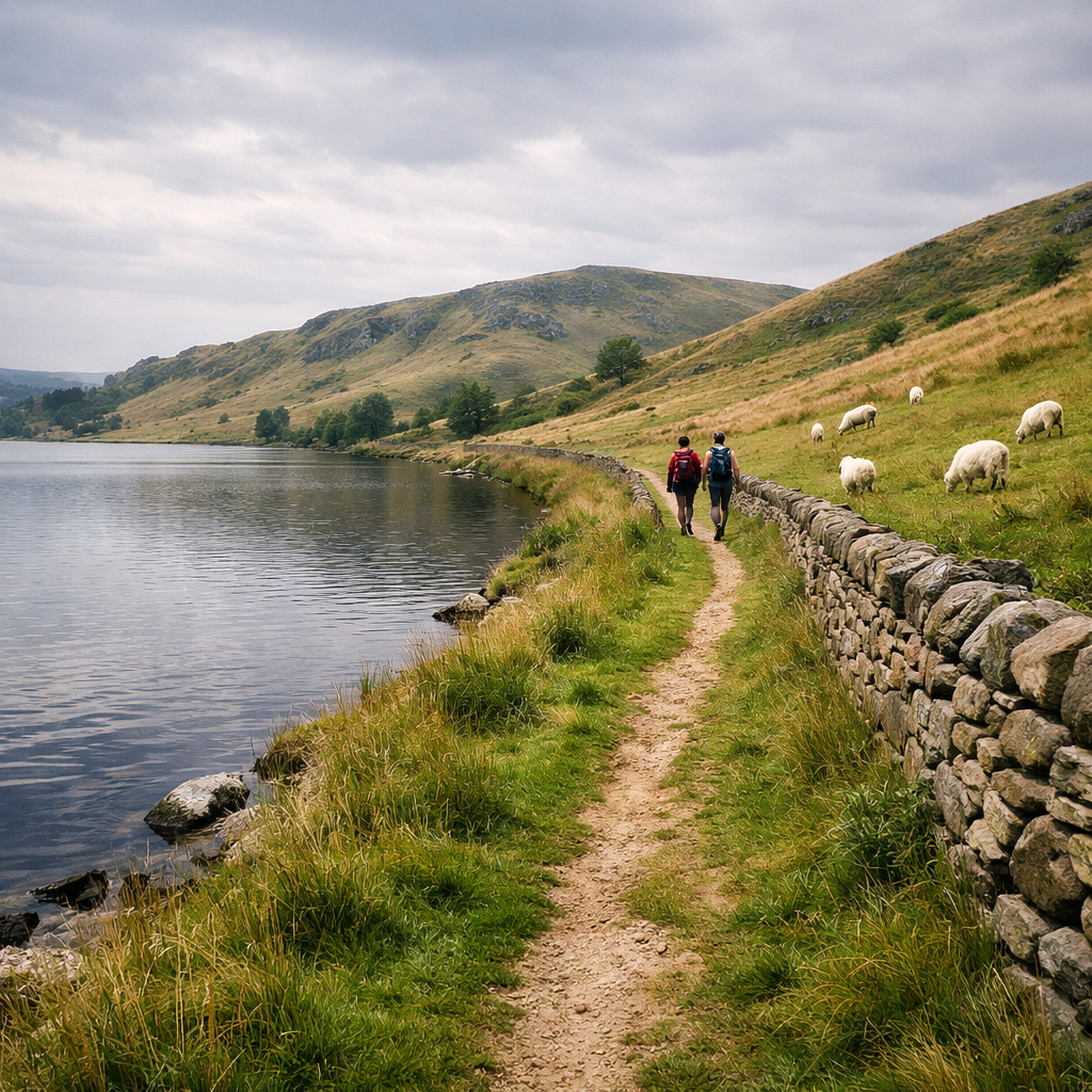
Quiet reservoirs and riverside loops
The Peak District’s waters split into three easy planning zones: west-side reservoirs (Longdendale chain with options around Winscar and Langsett), the Derwent Valley trio (Howden–Derwent–Ladybower), and limestone or woodland river dales (Chee Dale, Padley Gorge). Start with the calmer edges, then work inward with timing tactics.
Ladybower Reservoir
A scenic, relatively flat loop of about 9.2 km skirts Ladybower’s bays and bridges, with varied scenery that’s manageable for most beginners; if that’s too long, pick a shorter shoreline segment near the dams for a family-friendly taste, as described by Manchester Evening News. Terrain is hard-packed track with occasional road crossings. Use official car parks only, arrive early on weekdays, and never block verges—police ticket widely near honeypots. Quiet tip: walk counter‑clockwise to thin out at popular viewpoints.
Derwent Reservoir
Derwent offers gentle shoreline paths with spillway views and café/visitor facilities at Fairholmes. Try 5–8 km out‑and‑backs from the visitor centre on firm tracks suitable for most families. For experienced walkers seeking quieter terrain, a spur toward Alport Castles often feels less busy and wilder, as noted by Peak District hiking guides at House on Horizon (rugged ground; bring a map). Expect mixed-use paths and wind exposure across dams.
Howden Reservoir
The uppermost reservoir is the calmest of the Derwent trio. Build 6–12 km out‑and‑back segments on minimal-ascent tracks, staying alert for cyclists on the popular vehicle-restricted valley road. Quiet tip: start from northern access points and turn around before the main dam zone. Pack out all rubbish—litter remains a persistent park-wide issue.
Langsett Reservoir
A 5–6 km family-friendly loop circles woodland and moor-edge scenery on good tracks; in dry weather, sturdy buggies with chunky wheels can manage most sections. Park at the main Yorkshire Water car park and arrive outside peak family hours. Quiet tip: midweek late afternoons are blissfully quiet. If the lot is full, pivot to nearby Winscar or Stocksbridge-side trails—don’t wait or risk verge parking.
Winscar Reservoir
A breezier, less-visited alternative near Langsett, with 4–7 km circuits on firm, open tracks and big-sky views. There’s limited shade and frequent wind, so bring a light shell. Paths are shared—use a bell or clear voice cues when passing. Quiet tip: sunrise or weekday evenings feel almost empty.
Kinder Reservoir
Below Kinder Scout—the park’s highest plateau, rising above 2,000 ft and notorious for rough moorland—sits a tranquil reservoir framed by steep flanks. Keep your day gentle by staying valley-side: a 6–8 km out‑and‑back from Hayfield includes short, steeper sections on stone tracks; it’s not ideal for slim-wheeled strollers. Quiet tip: avoid bank holidays; go early or late midweek. Robbie Roams’ Peak District overview confirms Kinder’s stature and challenging terrain up top.
Dovestone Reservoir
An accessible perimeter loop of 4–5 km on good paths, with options to add easy moorland edges for extra distance. Facilities and signed routes suit beginners. Quiet tip: midweek mornings are best; keep dogs close around grazing stock. Pack in/pack out and avoid disposable BBQs due to fire risk.
Carsington Water
A facilities-rich choice with gentle bayside paths, play areas, and a visitor centre—great for first-timers. Stitch together short shoreline strolls or a partial loop on wide, shared-use trails. Quiet tip: begin from smaller satellite car parks away from the main hub and go in counter-peak hours. Listen for bike bells and keep to the left.
Chee Dale riverside
Shaded limestone walls, riverside paths, and stepping stones make Chee Dale a tranquil 4–8 km outing. Terrain is rooty and uneven with occasional slippery sections; families can enjoy it with care. Quiet tip: shoulder seasons or early starts reward you with echoes and birdsong. It’s a calmer alternative to the famously busy stepping stones at Dovedale.
Padley Gorge
SSSI (definition): A Site of Special Scientific Interest is a legally protected area for habitats, geology, or species of national importance. Any damaging activity is restricted, and visitors are asked to stay on durable paths, keep dogs under close control, and avoid littering to protect sensitive features.
Padley Gorge winds through ancient temperate rainforest—lush, mossy oak woods and tumbling streams—on shaded, rooty paths perfect for 3–6 km out‑and‑backs in warm weather. Start from Grindleford Station or Surprise View to vary gradients. Quiet tip: use lesser-known access points and arrive early on weekends.
Timing, travel, and parking for calmer trails
- When to go: weekdays, dawn starts, or late afternoons. Outside peak hours, even popular parts can be peaceful.
- Parking: enforcement is active around honeypots; if a lot is full, go elsewhere. Don’t block verges, lanes, or gates—expect tickets.
- Public transport: check rail/bus to valley hubs like Bamford, Edale, Grindleford, and Bamford/Ashopton for Ladybower. Borrow event tactics—time your day to train arrivals to cut congestion.
Offline navigation for beginner confidence
Download offline maps before you go. Most hiking apps—including Komoot and OsmAnd—let you save regional tiles, import a GPX, and set waypoints for car parks, toilets, and bail‑outs. The Hiking Manual 5-step workflow below keeps things simple if signal drops.
5-step offline workflow:
- Plan on Wi‑Fi and save your Komoot route or OsmAnd map tile.
- Download the GPX and add waypoints for parking, turn-backs, and cafés.
- Enable turn alerts or proximity alarms for junctions.
- Cache a satellite basemap for tricky junctions and dam crossings.
- Print a simple backup map and keep it dry.
GPX (definition): GPX is a lightweight GPS data format that stores tracks, routes, and waypoints. Because it’s plain text and open, you can share the same file across phones, watches, and mapping apps, making it ideal for offline navigation and consistent cues between devices.
Beginner-friendly gear for gentle lakeside walks
- Lightweight waterproof jacket (breathable) and a warm midlayer
- Supportive walking shoes with grippy soles; entry-level brands like Merrell, Saucony trail models, or NORTIV 8 work well if the fit is right—fit beats logo
- 10–15 L daypack, 1–2 L water, snacks, sunscreen, small first-aid kit
- Shared-path extras: a small bell or polite voice cues, and a compact headlamp in shoulder seasons
Safety, access, and Leave No Trace by the water
Carry out all litter—bins fill fast and littering is a persistent problem in the park. Hiking Manual backs Leave No Trace principles across our guides. Skip disposable BBQs due to fire risk; local outdoor bodies have even urged stronger restrictions in public spaces. Small shifts—earlier starts, quieter routes, and pack‑in/pack‑out habits—make a big difference. Ethical events model low-impact days with staggered starts and small teams; you can too.
Sample half-day itineraries
- Ladybower Dawn Loop (9.2 km): Start 06:30, park at Ashopton/Heatherdene. Walk counter‑clockwise; café stop at Bamford or Fairholmes after. Quiet pivot: drive 10–15 minutes to the upper Howden shoreline if parking is full.
- Derwent Riverside + Alport View (6–10 km): Start 09:00 at Fairholmes. Do a 6–8 km out‑and‑back; fitter walkers can add a short spur toward Alport Castles for a high viewpoint. Quiet pivot: shift to Howden’s north shore.
- Padley Gorge Shade Circuit (5–6 km): Start 08:00 from Grindleford Station. Streamside loop with a café treat at the station. Quiet pivot: move to Curbar or Froggatt Edge for airy views (arrive early; edges get busier later).
| Route | Distance | Elevation | Time | Terrain | Quiet Tip |
|---|---|---|---|---|---|
| Ladybower full perimeter | 9.2 km | <150 m | 2.5–3 h | Hard-packed tracks/road | Arrive at dawn; walk counter‑clockwise |
| Derwent shoreline out‑and‑back | 6–8 km | <120 m | 2–2.5 h | Firm mixed-use path | Start midweek; avoid dam peak times |
| Padley Gorge shaded circuit | 5–6 km | <150 m | 2–2.5 h | Rooty woodland path | Early start; use lesser-known access |
Frequently asked questions
Are these lakeside routes suitable for beginners and families?
Yes—most reservoir loops here are flat to gently undulating with options from 4–10 km. Choose shorter shoreline segments, start early, and bring snacks and layers for a relaxed, family-friendly day.
When are these trails quietest and how early should I arrive?
Weekday mornings are best. Aim to park by sunrise to 9am or visit late afternoon; if the car park is full, pivot to a nearby alternative rather than waiting or parking illegally.
What offline maps and apps should I use if signal drops?
Use an offline-capable map app and follow Hiking Manual’s 5-step workflow; download your GPX, save key waypoints, and carry a simple print backup.
What simple gear should I bring for a gentle, flat walk by water?
Wear supportive walking shoes and pack a lightweight waterproof, 1–2 L of water, snacks, sunscreen, a small first-aid kit, and a midlayer. Add a headlamp in shoulder seasons and a bell or polite voice cues on shared paths.
Are dogs allowed around reservoirs and rivers, and what etiquette should I follow?
Dogs are generally welcome but keep them on a lead near livestock and wildlife, and pack out waste. Give way on narrow paths and avoid letting dogs enter sensitive habitats or fast-flowing sections.
Peak District rescue figures and context reported by BBC • Crowd-avoidance and parking enforcement guidance via UKHillwalking • Ethical event timing to trains from Peak District Challenge • Ladybower 9.2 km loop detail in Manchester Evening News • Alport Castles as a quieter option noted by House on Horizon • Kinder Scout’s status and classic routes via Robbie Roams