Seven Sisters Tide Times 2026: Safe Windows For Beach Routes
Seven Sisters Tide Times 2026: Safe Windows For Beach Routes
Planning a beach section on the Seven Sisters requires more than a single timestamp. In 2026, the safest approach is to use a Seven Sisters–specific tide chart, pick a conservative low‑tide window, and build buffers for weather and pace. This Hiking Manual guide explains how semi‑diurnal tides shape your walking opportunities, how to read 2026 tide tables, and when to pivot to clifftop paths. We include clear safety direction for Cuckmere Haven, practical timing rules, and a micro checklist so you can set start and turnaround times with confidence. For day‑of verification, use authoritative, location‑specific predictions such as the Seven Sisters Tides page from WillyWeather, which shows two highs and two lows each day with ranges of several metres. Then apply the quick checks below from Hiking Manual.
How tide timing works at Seven Sisters
Semi-diurnal tides mean there are two high and two low tides in roughly 24 hours, with heights and times that shift daily. At Seven Sisters the tidal range is large, so beach width and access can change quickly. Example entries on the Seven Sisters tide chart show highs around 6.77 m at 01:16 and 6.66 m at 13:29, and a low near 0.73 m around 07:38—daily ranges of several metres (see the Seven Sisters Tides page on WillyWeather).
Think of the cycle like this:
- High tide → beach narrowest; access limited
- Falling tide → beach widens; currents easing
- Low tide → beach widest; weakest currents
- Rising tide → beach narrows quickly; currents strengthen
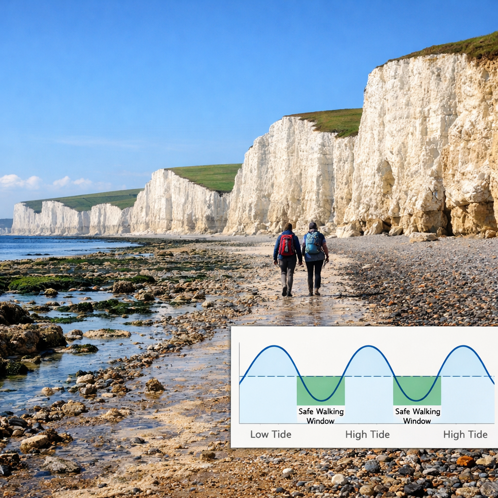
This range-and-timing pattern is why you plan for a safe tide window rather than a single crossing moment.
What a safe window means for beach routes
A safe window is the multi-hour period centered on low tide when the beach is widest and currents are weakest; it is not the exact low‑tide minute. Because the Seven Sisters’ tide range is large and varies day to day, your available low‑tide window can compress or expand with the moon phase and local conditions (as reflected on the Seven Sisters tide chart). Hiking Manual plans to the window, not the minute.
Mini-checklist to set your safe tide window:
- Confirm low tide for your exact date and location (Seven Sisters).
- Check window length: spring week (narrower) or neap week (wider).
- Add a safety margin for delays, photo stops, or detours.
Spring versus neap tides and why your window changes
Spring tides occur around new and full moons, bringing higher highs and lower lows. Conditions change faster and the safe window narrows. Neap tides occur around first and last quarter, reducing the range and often lengthening the safe window with more lateral beach space. At Seven Sisters’ large tide range, the spring-versus-neap difference is especially noticeable in how quickly the beach floods or drains (see WillyWeather’s daily range patterns). Hiking Manual tightens buffers on springs and stays conservative on neaps.
What changes between spring and neap:
- Window duration: shorter on springs; more forgiving on neaps
- Lateral beach space: tight on springs; wider on neaps
- Current strength: stronger on springs; milder on neaps
- Buffers: stricter on springs; still conservative on neaps
Reading 2026 tide tables for Seven Sisters
Use location‑specific 2026 tide tables for Seven Sisters—don’t rely on a nearby port. Expect two highs and two lows daily with ranges of several metres, and note how a lower low combined with a higher high compresses beach time (as shown on WillyWeather’s Seven Sisters page). Hiking Manual works from site‑specific tables paired with daylight to set turnarounds.
Step-by-step:
- Choose your date and confirm the Seven Sisters location.
- Note the low tide time and height (your window center).
- Note the preceding and following high tides (times/heights).
- Calculate the range (high minus low).
- Set start and turnaround times that keep you within your safe window and daylight.
Illustrative example for table reading (not actual predictions):
| Date (2026) | Low tide (time, height) | Preceding high (time, height) | Range (m) |
|---|---|---|---|
| 15 May | 08:02, 0.8 m | 01:20, 6.6 m | 5.8 |
| 15 May | 20:22, 1.1 m | 13:34, 6.4 m | 5.3 |
| 22 Aug | 06:47, 0.6 m | 00:58, 6.7 m | 6.1 |
| 22 Aug | 19:10, 0.9 m | 13:12, 6.5 m | 5.6 |
How to interpret:
- Lower lows plus higher highs = bigger range = window narrows and currents change faster.
- Modest ranges = longer low‑tide window and gentler transitions.
Planning buffers around low tide
Hiking Manual rule of thumb: arrive at the start of any beach‑dependent section 60–90 minutes before predicted low tide. Aim to clear committing points within 30–60 minutes after low, shortening that on spring tides or in rough weather. Adjust for group size, fitness, and photo stops.
Conservative buffers:
- Neap tides: arrive 90 minutes before low; latest turnaround 60–90 minutes after low.
- Spring tides: arrive 60 minutes before low; latest turnaround 30–45 minutes after low.
Tide times shift daily. Always verify the day’s Seven Sisters tide times and don’t rely on a single timestamp (see the Seven Sisters Tides page on WillyWeather).
Cuckmere river mouth hazards and approved crossings
The Cuckmere river mouth has fast, unpredictable currents and shifting channels. Local authorities warn there are no lifeguards and “it’s an unnecessary risk to enter the water,” with fast flow capable of sweeping people out or triggering cold‑water shock (see the BBC report on Cuckmere risks). Use the signed footpaths and bridges; do not wade or attempt informal crossings—even around low tide.
Key risks at the mouth:
- Shifting shingle bars change routes from week to week.
- Deeper channels after rainfall increase the hazard.
- Stronger ebb currents as the tide falls can knock you off your feet.
Weather, swell, and rainfall checks that affect currents
Onshore winds and swell can push water landward, delay drainage, and reduce beach width despite a favorable low-tide prediction. Storm surge and wave setup are well‑documented drivers of elevated water levels and rapid beach profile changes; verify conditions on the day (see the ASBPA coastal conference abstracts). Recent rainfall also strengthens the Cuckmere outflow, reshaping channels and increasing current speed (as highlighted in the BBC report on Cuckmere risks). If these factors stack up, Hiking Manual defaults to clifftop paths.
Pre‑walk checks:
- Wind direction/speed (onshore winds shrink usable beach).
- Swell height/period (longer‑period swell runs farther up‑beach).
- Rainfall in the past 48–72 hours (runoff boosts river flow).
- Daylight window and sunset time.
- Any cliff/landslide notices for the area.
Out-and-back timing for popular sections
If your low‑tide window is tight, choose shorter out‑and‑backs or switch to clifftop paths. The full Seaford‑to‑Eastbourne route via Cuckmere Haven, Birling Gap, Belle Tout, and Beachy Head is roughly 21.2 km with sustained ups and downs, best reserved for a big window and solid fitness (see Country & Town House’s overview of the Seven Sisters hike).
Typical beginner‑pace timing (3–4 km/h):
- Seaford to Cuckmere Haven and back: 1.5–2.5 hours; target low tide ±60 minutes.
- Birling Gap beach exploration (down-and-up): 30–60 minutes within the low‑tide window; exit before the tide turns.
- Belle Tout section (clifftop): 1–2 hours out‑and‑back; ideal fallback when the beach window is narrow.
- Seaford to Eastbourne route time (full Seven Sisters): 6–8 hours; plan as a clifftop day unless you have generous neap‑tide windows and stable weather.
Essential safety kit for coastal walks
- Navigation: OS map/app with offline tiles; set key waypoints and escape routes.
- Comms: phone in a waterproof case; whistle; headlamp for late exits.
- Layers: waterproof layers, warm midlayer, hat/gloves in shoulder seasons.
- Essentials: 1–2 L water, high‑energy snacks, compact first‑aid kit, emergency blanket, basic repair tape.
- Poles: trekking poles for shingle (aluminum or carbon, quick locks, cork grips).
- Rest/shelter: lightweight hammock with tree‑friendly straps for breaks away from surf; a winter‑ready 4‑season tent only if bivvying is permitted—always check local rules.
- Emergencies: dial 999 and ask for the Coastguard; give location and description.
Quick checks before you set off
- Confirm today’s Seven Sisters tide table (low/high times and tide height). Screenshot the chart for offline use.
- Identify whether you’re in a spring or neap week.
- Set start and turnaround times with conservative buffers.
- Check wind, swell, and rainfall runoff effects.
- Choose clifftop alternatives; avoid any Cuckmere Haven crossing at the river mouth.
- Share your walk plan and ETA with a contact.
- Pack the emergency coastal kit and key numbers.
Frequently asked questions
How can I check tide times before attempting the Seven Sisters walk?
Use a Seven Sisters–specific tide table for your date, cross‑check with a second source, and screenshot the chart. Hiking Manual’s quick checks in this guide help set start and turnaround times.
How close to low tide should I time a beach route?
Start 60–90 minutes before low tide and aim to finish within 30–60 minutes after, shortening the window during spring tides or rough weather; these are Hiking Manual’s standard buffers.
Can I cross the Cuckmere river mouth at low tide?
No. Follow the signed footpaths and bridges; currents and channels shift quickly and wading is dangerous even around low tide. Hiking Manual advises using the bridges year‑round.
Do spring tides make the walk unsafe?
Not automatically, but windows are tighter and currents stronger; use stricter buffers or choose clifftop alternatives if your group is slower or visibility is poor. Hiking Manual tightens buffers on springs and often switches to clifftops when conditions are uncertain.
Who do I call in an emergency on the coast?
Dial 999 and ask for the Coastguard; provide your location and details, then follow their instructions.