Seven Sisters Tide Tables: Reliable Sources, Timing Windows, Safety Tips
Seven Sisters Tide Tables: Reliable Sources, Timing Windows, Safety Tips
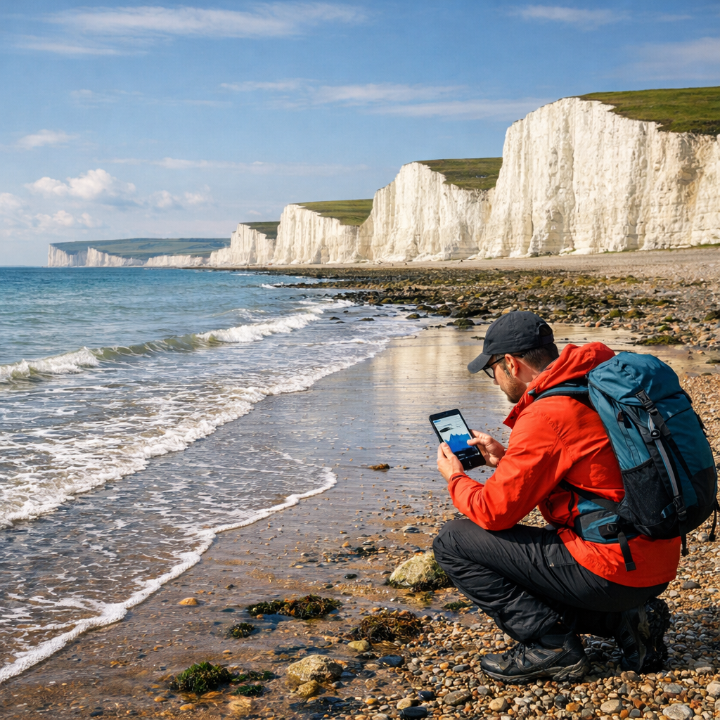
Planning the Seven Sisters walk means planning around the tide. If you want time on the beach at Cuckmere Haven or Birling Gap, or to photograph cliff bases safely, check a local tide page that lists coordinates and time zone, confirm the source station, and cross-check with a second provider. Then build a buffer: finish any beach or cliff-base sections 60–120 minutes before the published high tide. Because wind and pressure can raise or lower real water levels compared with the table, always scan weather advisories alongside your tide chart. At Hiking Manual, we treat these as non‑negotiable steps. The clifftop South Downs Way between Eastbourne and Seaford (about 22 km/14 miles) stays walkable at any tide, but shoreline detours do not. The steps below show how to choose reliable Seven Sisters tide tables for hiking and turn them into a safe day plan.
Why tide timing matters at Seven Sisters
Beaches, ledges, and estuary margins along the Seven Sisters can go from open shingle to impassable in a few hours. At Cuckmere Haven, the river mouth and surf compress the usable beach; at Birling Gap, wave run-up reaches the cliff foot quickly on springs. Accurate Seven Sisters tide times guide whether you stay high on the South Downs Way or dip to the shore—and when you must leave the beach to avoid a cut-off.
Tide tables are a baseline forecast; real levels shift with weather. Municipal and NOAA-style advisories note that prolonged onshore winds and low barometric pressure can elevate sea levels above predictions, while offshore winds and high pressure can depress them—so plan buffers generously and expect variance in Seven Sisters tides today, especially near high tide Seven Sisters (Fort Lauderdale high‑tide guidance).
“Tide table: a schedule of predicted high and low water times and heights for a location, calculated from astronomical cycles. It’s a planning baseline, not a guarantee; weather and surge can shift real-world levels.”
How tide predictions work
Astronomical tide predictions use the moon, sun, and local harmonics to forecast the timing and height of high and low water. They assume average weather and no storm surge, so wind, pressure, river flow, and bathymetry-driven dynamics can shift actual levels and inundation (NOAA Sentinel Site guidance).
Aggregated services often derive their tables from the nearest official station. At a specific cove or beach, the published times can be offset by minutes and the heights by tens of centimeters. Trust providers that display station metadata, distance, and “not for navigation” disclaimers, and always check for offsets and alert banners (Windfinder tide pages).
Plan conservatively for the long term, too: global sea level has risen about 7–8 inches since 1900, with nearly half since 1993; best estimates project 1–4 feet by 2100, with up to 8 feet possible in high-end scenarios—extremes tighten safe windows on coasts like East Sussex (Hoover Institution coastal resilience report).
Reliable tide sources for Seven Sisters
Hiking Manual favors pages that are specific, transparent, and weather-aware.
- SeaTemperature: The Seven Sisters spot page lists coordinates (around 50.78, 0.06), Europe/London time zone, and states predictions are astronomical and can vary with storms, wind, and pressure. That clarity helps you plan low tide at Cuckmere Haven and read the Seven Sisters tide chart in context (SeaTemperature Seven Sisters tides page).
- Windfinder: Tide pages show severe-weather banners, “predictions without warranty/not for navigation,” the nearest station name and distance (e.g., a sample view notes a station a few km away), and unit controls—useful cues when checking a broader East Sussex tide forecast (Windfinder tide pages).
If you prefer a UK tide table app, look for the same features: station ID, distance/offsets, time zone, and prominent weather notices.
How to check and cross‑check tide times
Pick a Seven Sisters–specific page that lists coordinates and time zone, and confirms predictions are astronomical with weather caveats (SeaTemperature Seven Sisters tides page).
Verify the source station and distance/offsets; note any “nearest station” labels and alert banners (Windfinder tide pages).
Cross-check times and heights on a second provider. Align on the sequence and approximate magnitudes for the day (e.g., low ~03:25 1.72 m, high ~09:28 4.23 m, low ~15:52 1.39 m, high ~21:59 4.48 m) (SeaTemperature Seven Sisters tides page).
Scan for severe-weather or king-tide advisories and extend buffers if onshore winds/low pressure are forecast (Fort Lauderdale high‑tide guidance).
This 3‑step cross‑check is the baseline we use at Hiking Manual.
Practical add-ons:
- Save offline screenshots of the tide tables and set calendar alerts 2 hours before each high tide.
- Sketch a simple plan like this:
| Window | Times and heights (example) | Plan | Safety buffer |
|---|---|---|---|
| Morning beach window | Low ~03:25 1.72 m → High ~09:28 4.23 m | Start 06:30; leave beach by 08:00 | 90 minutes before high |
| Midday high‑tide period | Around 09:28 high | Stay on clifftop paths | 60–120 minutes clearance |
| Evening beach window | Low ~15:52 1.39 m → High ~21:59 4.48 m | Photos at Cuckmere 16:30–17:30; turn back by 20:00 | 120 minutes before high if onshore winds |
Timing windows for the walk and beach sections
Rules of thumb that translate a Seven Sisters tide table into go/no-go decisions:
- Finish any beach or cliff-base section 60–120 minutes before the published high tide to avoid getting cut off. Increase the buffer during onshore winds or low pressure because real levels can exceed predictions (Fort Lauderdale high‑tide guidance).
- The most forgiving window for beach exploration is from low tide through the first hour of the flood. Avoid committing to long shoreline traverses during the last 2 hours before high tide.
Spring vs. neap tides: Spring tides occur near full or new moon and have larger ranges; neap tides occur near quarter moons and have smaller ranges. Larger ranges shorten safe beach windows; smaller ranges widen them.
Sample day using the example highs/lows:
- Morning: With high at ~09:28, aim to be off any beach by ~08:00–08:30. A 06:30 start from Seaford gives time for photos near the river mouth and a relaxed exit to the cliffs.
- Mid-route: Stay high across the undulating chalk tops during the late flood and around high water.
- Evening: Low at ~15:52 opens another shore window. If you want Birling Gap beach access, be climbing back to the steps by ~20:00 to keep a 120-minute buffer before the ~21:59 high.
Special considerations at Cuckmere Haven
Where the Cuckmere River meets the Channel, estuary flow and surf can locally raise levels and speed up cut-offs. Use the published tide height plus a conservative buffer—especially with onshore winds or low pressure—because actual water can exceed the Seven Sisters tide times you saw earlier (Fort Lauderdale high‑tide guidance). Hiking Manual treats Cuckmere as a strict cut‑off zone and plans exits early.
Plan alternatives:
- When tides are near the day’s high, choose the clifftop South Downs Way instead of shoreline shortcuts.
- Avoid attempting low-lying crossings on the shingle bar late in the flood; retreat to marked paths.
Quick comparison:
- Low tide: broader shingle exposure and easier photo access—still monitor the incoming tide.
- High tide/king tide: reduced beach and faster cut-off risk—stick to clifftop routes and signed detours.
Weather factors that change predicted tides
- Prolonged onshore winds and low barometric pressure can produce higher water levels than predicted; offshore winds and high pressure can lower them relative to the astronomical curve (Fort Lauderdale high‑tide guidance).
- Storm surge: wind- and pressure-driven rise in water level above the astronomical tide, elevating flood and erosion risk for hours.
- Before departure, check for severe-weather banners or alerts within your tide app/site and expand your buffers to 120+ minutes if any warnings are displayed (Windfinder tide pages).
Safety guidance for cliffs, surf, and estuary crossings
- Water safety: Never swim alone; even strong swimmers should use a buddy. Drowning can be silent with a blank stare, and you may have less than 30 seconds to reach a victim; carry a charged phone and learn CPR (CHOC drowning prevention guide).
- High or king tides: Avoid low-lying paths and never walk/drive through floodwater; note that higher tides reduce bridge clearance for boaters—check before launching or returning (Fort Lauderdale high‑tide guidance).
- Cliff safety Seven Sisters:
- Stay well back from the edge and avoid overhangs; chalk can be undercut after storms.
- Keep dogs on lead near edges and heed closure signs.
- Do not climb unstable faces to escape waves—seek higher ground via paths.
If cut off unexpectedly:
- Move to higher ground immediately.
- Avoid climbing crumbly or wet cliff faces.
- Call local emergency services and give your location.
- Signal with bright clothing or a headlamp.
- Once safe and visible, stay put until help arrives.
Quick gear checklist for coastal conditions
- Footwear with strong grip for wet chalk and shingle; lightweight waterproof shell; warm layers for wind chill.
- Safety: fully charged phone in a waterproof pouch, headlamp, small first-aid kit, emergency foil blanket, and a basic hiking compass.
- Carry: 15–25L daypack made from recycled or hemp fabrics; refillable bottle(s), snacks, printed map; optional small dry bag for electronics.
- Clothing: lightweight summer hiking pants in inclusive fits (elastic/adaptive waist, real pockets), cap, sunglasses, reef-safe sunscreen.
- Stability: beginner trekking poles (e.g., lightweight aluminum like TrailBuddy) for steep, loose descents.
Frequently asked questions
What tide station should I use for the Seven Sisters area?
Hiking Manual recommends a Seven Sisters–specific page that lists local coordinates/time zone and shows the source station and distance. Confirm any “nearest station” notes and check for alert banners before you go.
How early should I finish a beach or cliff‑base section before high tide?
Aim to finish 60–120 minutes before the published high tide. Hiking Manual advises increasing the buffer when onshore winds or low pressure are forecast since real water levels can exceed predictions.
What is the difference between spring, neap, and king tides?
Spring tides (around full/new moon) have larger ranges; neap tides (quarter moons) have smaller ranges. King tides are the highest spring tides of the year and can elevate sea levels for hours, so Hiking Manual plans extra caution and time buffers.
Do wind and pressure change the published tide times or heights?
Yes. Onshore winds and low pressure can raise water levels above predictions, while offshore winds and high pressure can lower them; Hiking Manual always checks weather advisories alongside the tide table.
Is the Seven Sisters route safe at high tide if I stay on the clifftop path?
Generally yes, if you stick to signed clifftop paths and give cliff edges a wide berth. Hiking Manual recommends avoiding low-lying beach sections around high tide and following any local closures or warnings.