London–Brighton Cycle Route Elevation Profile: Trusted Services for 2026
London–Brighton Cycle Route Elevation Profile: Trusted Services for 2026
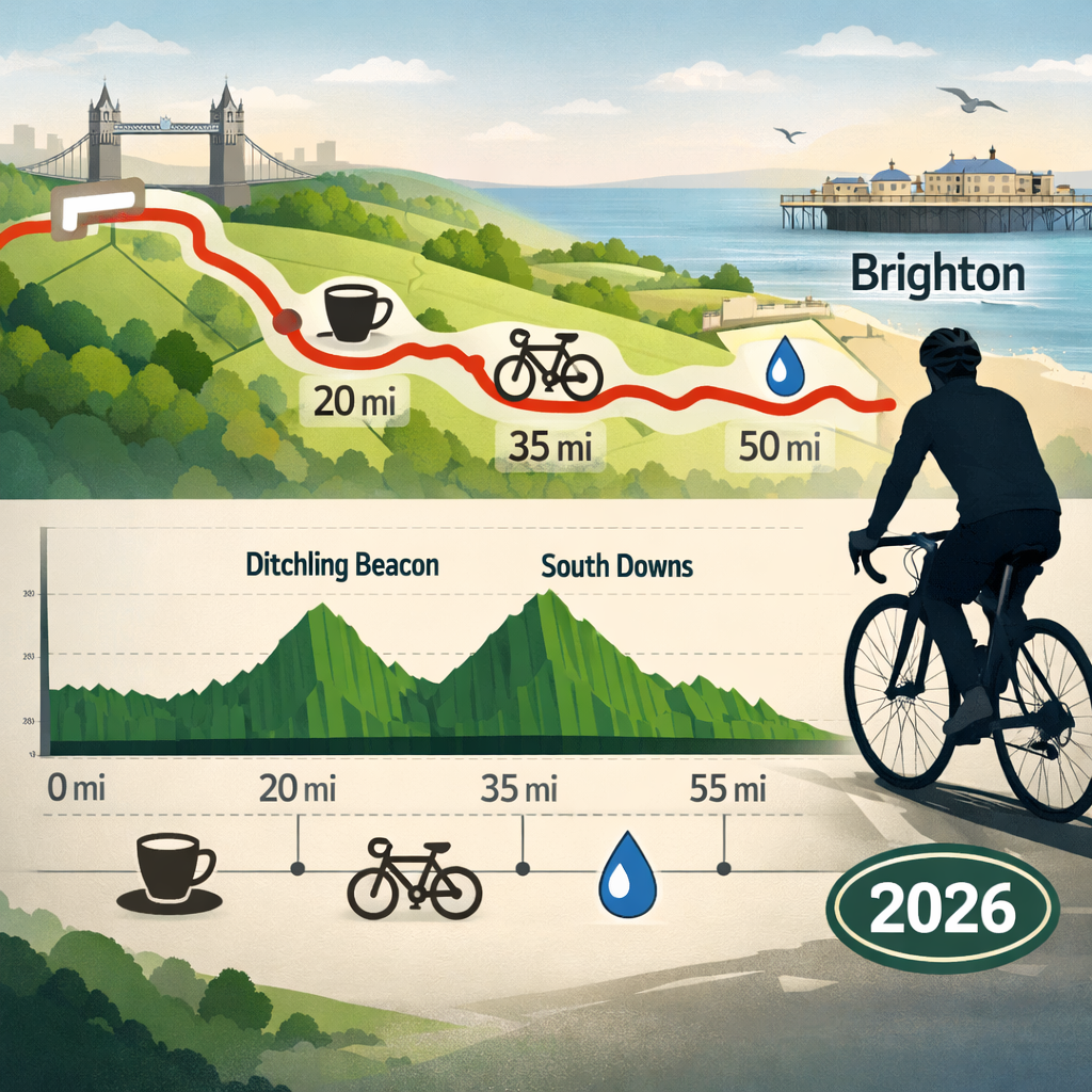
Planning London to Brighton and want to see the elevation profile before you ride? Here’s the fast answer and the reliable tools we use at Hiking Manual. The classic road variant runs 54–55 miles from Clapham Common to Brighton seafront; charity versions are fully supported, well‑signed, and family‑friendly, with thousands taking part each year. The defining effort is the late‑ride ascent of Ditchling Beacon, followed by a long descent to the coast, so previewing the profile helps you pace smartly and fuel well. Below, we share the best free and low‑cost services to view the London to Brighton cycle route elevation profile, compare variants, and download a GPX for your bike computer—plus practical tips for gear, safety, and 2026 event logistics based on current organiser guidance from the BHF road ride and off‑road editions, and other major charity events.
Quick answer
- Hiking Manual’s top pick: Komoot shows a clear, interactive elevation profile for London–Brighton routes, with surface types, gradients, and difficulty, and is free to view on web and app. It doubles as a route planner and makes GPX download straightforward.
- Runner‑ups:
- Ride with GPS: robust route libraries and precise Elevation tab with color‑graded climbs; great control over GPX/TCX exports.
- Strava Routes: strong for segment grades and Heatmap‑based line choice; helpful Beacon segment pages for pacing.
- Context: the organised road ride is 54–55 miles from Clapham Common to the Brighton seafront, so elevation profiles vary slightly by variant and event routing (see the BHF road ride details and FAQs; also note distance on the Alzheimer’s Society ride page) (BHF London to Brighton Bike Ride; Alzheimer’s Society London to Brighton).
Route overview and elevation highlights
The standard road route runs roughly 55 miles from Clapham Common to the Brighton seafront, with the BHF full ride listed at 54 miles. Expect rolling south‑London and Surrey lanes, a quiet middle section, then the South Downs ridge and Ditchling Beacon before the sweeping coastal descent to the finish (BHF London to Brighton Bike Ride; Cycling UK route overview).
An elevation profile is a side‑view chart of a ride’s altitude over distance, highlighting total ascent and descent, steep sections, and where climbs begin and end. Interactive profiles add gradient color, surface types, and waypoints, helping you plan pacing, nutrition timing, and gear selection before you roll.
Highlights by profile:
- Rolling early miles, manageable gradients, and mostly paved surfaces.
- The signature late‑ride South Downs climb at Ditchling Beacon (about 1–1.6 km depending on line).
- A long, restorative descent into Brighton, where wind direction can shape finish speed.
Ditchling Beacon climb
Ditchling Beacon is a mile‑long climb on the London–Brighton route and the signature elevation challenge just before the coast. It rewards steady pacing and low gears; most profiles show a sustained ramp rather than savage spikes (Cycling UK route overview).
A climb profile isolates one ascent’s distance, vertical gain, and average/maximum gradient, often with segments and surface switches. Reading it helps you choose compact gearing, estimate effort and cadence, and decide where to conserve energy or eat a gel so you crest without blowing up.
Practical prep:
- Fit compact or sub‑compact gearing and check brake pads for the fast post‑summit descent.
- Include short hill intervals in training, and plan a gel/water stop before the Beacon.
- On big charity rides, mechanics and water/toilet stops support you on route, reducing stress on the day (Alzheimer’s Society London to Brighton).
Trusted services that show elevation profiles
Use these tools to view the London to Brighton cycle route elevation profile, compare gradients, check surface types, and export GPX.
Komoot (best for free elevation and surfaces)
- Clear, interactive elevation graph with gradient shading; detailed surface and waytype layers.
- One‑click GPX export after login; offline navigation with Premium.
- Event‑relevant collections around Brighton help plan 2026 rides (Komoot SmartTour: London to Brighton; Komoot cycling around Brighton & Hove).
Ride with GPS (best for route libraries and metrics control)
- Elevation tab with climb stacks and grade coloring; filter community routes by distance/surface.
- GPX/TCX export; advanced features require a paid plan.
- Helpful for comparing multiple variants (Beacon vs alternatives) side‑by‑side.
Strava Routes (best for social segments and Heatmap)
- Elevation totals plus segment‑grade insight; global Heatmap helps pick the most‑ridden line (often via the Beacon).
- Segment pages show grade distribution and recent activity for pacing practice.
- Note: event‑day closures/marshalling may differ from typical public routing.
OS Maps (best for terrain context)
- Contours and terrain shading make the South Downs ridge and Beacon obvious at a glance.
- Pair a GPX from another app to get both a profile and full topo clarity; subscribers can export routes.
- Useful for checking rights of way if exploring bridleways or byways.
Remember: official event routes are fully sign‑posted with marshals and rest stops, so many riders won’t need to follow a device on the day, but previewing the elevation is still invaluable for pacing and nutrition (Sue Ryder London to Brighton event notes).
Table: quick comparison
| Service | Elevation clarity | Surface data | GPX export | Offline use | Pricing/free tier | Best for |
|---|---|---|---|---|---|---|
| Komoot | High | Yes | Yes | Yes (Premium) | Free + Premium | Free elevation + surfaces |
| Ride with GPS | High | Basic tags | Yes | Via head unit apps | Free + Paid | Libraries + detailed metrics |
| Strava Routes | Medium–High | Limited | Yes | Via head unit apps | Free + Premium | Segments + Heatmap |
| OS Maps | Medium (topo view) | Contours/topo | Yes (Premium) | Yes (Premium) | Free + Premium | Terrain context |
Komoot
Why it’s Hiking Manual’s top pick: Komoot combines an interactive elevation profile with gradient coloring, surface types, and difficulty ratings—ideal for assessing the Beacon and the long coastal descent. Its Brighton/Hove ride pages and curated SmartTours are current and practical for 2026 planning (Komoot SmartTour: London to Brighton; Komoot cycling around Brighton & Hove).
How‑to:
- Search “London to Brighton” or build from Clapham Common to the Brighton seafront.
- Toggle Surface and Waytype layers; note total ascent and key climb sections.
- Save and export GPX for your bike computer (login required).
Limitations: profiles vary with the exact path (e.g., detours to avoid busy roads). If joining an organised ride, cross‑check against the organiser’s GPX and notes.
Ride with GPS
Use the search to find “London to Brighton” routes; filter by distance (54–61 miles) and paved/off‑road to match your variant. Open the Elevation tab to see climb stacks and grade colors. Compare several community routes to visualise how the Beacon (and any alternatives) plot in the profile. Export GPX/TCX as needed; some advanced features require a paid plan. For families and beginners, choose routes with fewer high‑grade spikes and more evenly distributed ascent.
Strava Routes
Create a route from Clapham Common to Brighton, enable Elevation to see total ascent and grade spikes, and overlay the Heatmap to follow the most popular lines, which typically include Ditchling Beacon. Check the Ditchling Beacon segment page for grade distribution and recent rides, then bookmark it to pace your effort relative to segment splits. Caution: event‑day roads may be closed or marshalled, so profiles reflect typical public routing rather than closures.
OS Maps
Use contours and terrain shading to visualise where the South Downs ridge creates the Beacon climb, then pair with a GPX from another app for a full profile plus topo context. If you’re considering off‑road variants, check rights of way (bridleways, byways) and confirm surfaces before committing with a group or family.
Cycling UK planner
Cycling UK’s route features offer context on terrain, iconic climbs like Ditchling Beacon, and what to expect on British day rides—use their insights to frame difficulty and pair with an app‑based elevation profile for precise pacing (Cycling UK route overview).
How to view and compare elevation profiles step by step
- Pick a service (Hiking Manual recommends Komoot for free elevation and surfaces).
- Enter start “Clapham Common” and finish “Brighton seafront.”
- Toggle surface/waytype layers and choose quieter roads or cycleways.
- Note total ascent, the biggest climb length, and average/maximum grade.
- Save the route and export GPX; sync to your head unit.
Cross‑check with a second app to confirm the Beacon appears late in the profile and total distance matches roughly 54–55 miles for the classic road ride. If you’re doing a charity event, download the organiser’s GPX and remember routes are fully sign‑posted with marshals and mechanics, reducing reliance on navigation (Sue Ryder London to Brighton event notes; Alzheimer’s Society London to Brighton).
Choosing a route variant by elevation and surface
- Classic road sportive: 54–55 miles from Clapham Common, Ditchling Beacon late, long descent to the seafront; suitable for fit beginners with steady pacing (BHF London to Brighton Bike Ride; Alzheimer’s Society London to Brighton).
- Off‑road: 61 miles from Apps Court Farm to Hove Lawns; mixed surfaces (hardpack, dirt, gravel, roots, sand, stones) and staggered starts to spread riders (BHF London to Brighton Off‑Road).
- Midway start option (off‑road): Cranleigh to finish (about 36.5 miles) with the same mixed‑surface character (BHF London to Brighton Off‑Road).
Surface type describes the ground you ride on—paved tarmac, hardpack, gravel, sand, or mixed. It directly affects rolling speed, traction, and comfort. Matching tyre width and pressure to the expected surface reduces fatigue and punctures while improving control on both climbs and long descents.
Families and newer riders: favor paved routes with steadier gradients, and preview profiles to locate any single long climb to plan a regroup or fuel stop before it.
Safety and seasonality on the downs
Large charity events are typically well‑managed: signage and marshals keep riders flowing, and road closures can cover a substantial portion—often around 60%—depending on the year and permissions (London to Brighton Bike Ride overview; Sue Ryder London to Brighton event notes). Expect wind and cooler air on the exposed Downs; mechanical/medical support and water/toilets are common at stops to reduce risk and stress (Alzheimer’s Society London to Brighton). For training rides, leverage protected Cycleways and best‑practice urban infrastructure to stay safe off‑peak before tackling rural lanes (TfL best‑practice study).
Beginner and family-friendly planning tips
- Use a 16‑week plan and targeted “Beat the Beacon” hill guidance from event organisers; practice fueling before climbs and ride at a chatty pace early (BHF London to Brighton Bike Ride).
- Inclusive entries exist: fully accessible 55‑mile “No Limits” rides welcome handcyclists—check registration and sponsorship details if fundraising (No Limits accessible ride).
- For families: pick later waves or midway starts where offered, set regroup points at water stops, and prioritise routes with one main climb rather than multiple spikes.
Budget gear checklist for a windy, hilly day
- Lightweight windproof/waterproof shell; merino or light fleece base layer; full‑finger gloves with good grip.
- Compact multi‑tool, two tubes, mini‑pump or CO2, and tyre levers; check brake pads and wheel true for the final descent.
- Two bottles plus on‑bike food; a small top‑tube bag makes it easy to grab a gel before the Beacon.
- Even with mechanics and water/toilets at charity‑ride stops, carry essentials to avoid delays between points (Alzheimer’s Society London to Brighton).
Transport and logistics with elevation in mind
Common offerings include coach travel to the start, bag transfer, on‑route support (“Ride Rangers” or similar), and recovery transport if fatigue or mechanicals end your day early—build small buffers so you’re not rushed ahead of the Beacon (BHF London to Brighton Bike Ride). Some events also sell optional coach+bike transport; confirm timings and packing needs when booking (Alzheimer’s Society London to Brighton). Off‑road editions use staggered starts (every 15 minutes from 06:30 to 09:15), which space riders before key climbs and affect when you’ll hit the Downs (BHF London to Brighton Off‑Road).
Frequently asked questions
How much climbing is on the London to Brighton route?
Expect rolling elevation with the signature Ditchling Beacon late in the ride. On organised road variants of 54–55 miles, ascent is moderate for fit riders; exact totals vary by route choice and wind on the Downs.
How steep is Ditchling Beacon and can beginners ride it?
Ditchling Beacon is roughly a mile (≈1.6 km) and steady rather than ultra‑steep. With low gears, short hill repeats in training, and a gel and water before the base, determined beginners can ride it at a comfortable pace.
Which app shows the clearest elevation profile for free?
Start with a free, interactive route planner that shows elevation and surfaces; at Hiking Manual we favor clear profiles and simple GPX export. Then compare the same route in a second app for confirmation.
How do I download a GPX with elevation for my bike computer?
Build or open the route in a planner, save it, then export GPX/TCX and sync to your head unit via app or USB. Hiking Manual tip: verify the profile shows the Beacon late in the ride before event day.
What gearing and brakes are best for the Beacon and the final descent?
Use compact or sub‑compact gearing and a wide‑range cassette for the Beacon, and ensure fresh pads and true wheels for the coastal descent. We suggest a short test ride to check shifting and braking the week before.