First-Timers’ Guide: Complete Seven Sisters Walk Time and Tips
First-Timers’ Guide: Complete Seven Sisters Walk Time and Tips
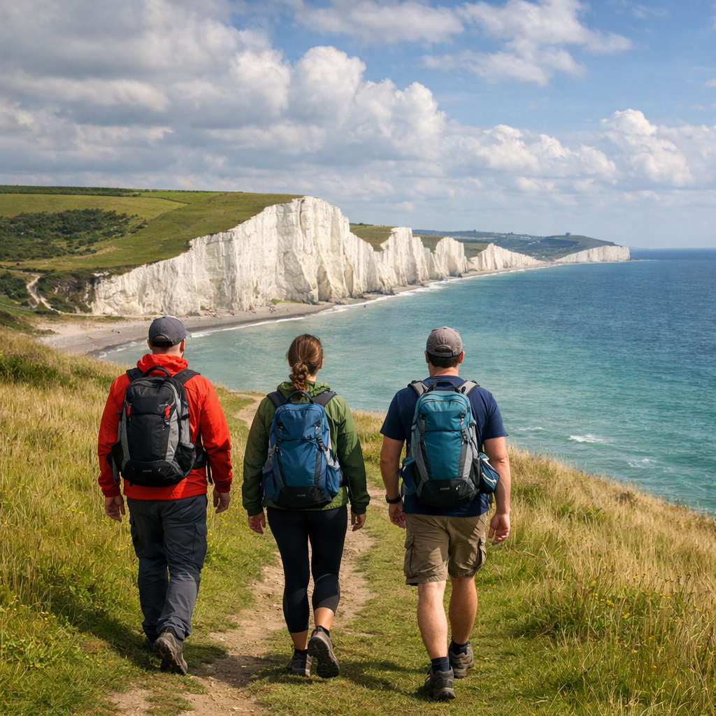
The complete Seven Sisters coastal walk from Seaford to Eastbourne is a full-day classic that most first-timers finish in 4.5–7 hours, depending on pace, the Cuckmere Haven tide, weather, and photo stops. Faster hikers report ~4h30 for a 12.3-mile day, while the classic 22 km route takes 6–7 hours. See timing evidence from Flamingo Hiker and Scenic Route Traveler, plus tide impacts summarized by Anywhere We Roam. This Hiking Manual guide gives you the route, time factors, and simple decisions to finish comfortably in daylight.
Overview and typical time
Most first-timers should plan 4.5–7 hours for Seaford to Eastbourne. Faster completions around 4h30 are reported on the 12.3-mile/19.8 km line with ~469 m ascent, while 6–7 hours is common for the classic 22 km/13.6-mile route with ~621 m gain (supported by Flamingo Hiker’s Seven Sisters guide and Scenic Route Traveler’s overview). Typical day hike pace is 3–5 km/h (2–3 mph) on varied terrain, including time for quick photos and water. On the Seven Sisters, short, steep grass climbs and descents recur all day, so your average speed will be lower than on flat paths.
Quick time factors:
- Cuckmere Haven tide choice (±50 minutes)
- Wind and weather exposure on the chalk downs
- Fitness and group size
- Time spent at big viewpoints (Seaford Head, Birling Gap, Beachy Head)
For more on the tide-time delta and route nuances, see Anywhere We Roam’s route details.
Route options and distance
Two well-cited totals frame expectations:
- 12.3 miles (19.8 km) with ~1,539 ft/469 m ascent (often with a low-tide beach crossing at Cuckmere) per Flamingo Hiker.
- 13.6 miles (22 km) with ~2,037 ft/621 m gain (classic route via inland crossing and full headland finish) per Scenic Route Traveler.
Why distances vary:
- Low-tide beach crossing at Cuckmere vs the inland bridge detour
- Short detours to viewpoints
- Finishing at Beachy Head vs continuing to Eastbourne Pier/station
| Option | Distance | Elevation gain | Typical time | Tide dependency | Notes |
|---|---|---|---|---|---|
| Low-tide beach crossing, finish Eastbourne seafront | ~12.3 mi / 19.8 km | ~469 m | ~4.5–5.5 h | Needs low tide window | Shortest full traverse; classic postcard views all day |
| Inland bridge via Seven Sisters Country Park, finish Eastbourne | ~13.6 mi / 22 km | ~621 m | ~6–7 h | Works at any tide | “Classic route”; adds inland marsh detour time |
| Finish at Beachy Head (bus to Eastbourne) | ~10.5–11.5 mi / 17–18.5 km | ~500–600 m | ~4–6 h | Either tide | Cuts final seafront miles; good bailout in poor weather |
Step 1: Check weather and tide times
Check the Met Office forecast and the tide times for Cuckmere Haven and Birling Gap before you set off (route and planning notes in Scenic Route Traveler’s Seven Sisters overview). Strong winds on exposed chalk cliffs can slow you and make edges hazardous. Hiking Manual plans around the low-tide window when conditions and timing allow.
Low tide crossing at Cuckmere (definition): At low tide, you can walk across the Cuckmere River mouth on firm sand to rejoin the cliffs directly. The window is brief and water levels rise quickly with the turn. When feasible, this shortcut trims distance and saves meaningful time compared with the inland bridge detour.
Time impact: the beach crossing can save about 50 minutes and almost 2 miles; at high tide the inland paths commonly add 30–60 minutes, depending on route choice (as summarized in Anywhere We Roam’s route details and echoed by Flamingo Hiker).
Step 2: Plan transport and start early
Rail is simple: London Victoria to Seaford typically takes about 1.5 hours with a change at Lewes, and Eastbourne back to London Victoria is often a direct ~1h30 (timings noted in Flamingo Hiker’s guide). Start between 8–9 AM to secure parking, beat crowds, and bank daylight (timing advice in Scenic Route Traveler).
Coastal buses (public transport on the Seven Sisters) offer flexible starts/finishes: Coaster routes 12/12A/12X/13X link Brighton, Seaford, Seven Sisters Visitor Centre, Birling Gap, and Eastbourne (see route mentions in the Petite New Yorker trip notes and this Rick Steves community planning thread). If you rail both ways, consider split tickets (London→Seaford; Eastbourne→London).
Step 3: Follow the route from Seaford to Eastbourne
Why west-to-east? Walking Seaford→Eastbourne keeps the white cliffs in constant view ahead—arguably the most photogenic direction (an approach endorsed in Scenic Route Traveler). Hiking Manual prefers this direction for first-timers. From Seaford station it’s about 10 minutes on foot to the Esplanade start (timing noted by Anywhere We Roam).
Step-by-step overview:
- Seaford Esplanade → up to Seaford Head
- Down to Cuckmere Haven
- Seven Sisters Country Park/Visitor Centre (if using inland route)
- Birling Gap
- Belle Tout Lighthouse
- Beachy Head
- Eastbourne seafront → Eastbourne station
Navigation confidence: Paths are obvious in fair weather, but hill repeats make time drift. Hiking Manual recommends downloading OS Maps for offline use; mobile signal can be patchy in places (a tip highlighted by Scenic Route Traveler).
Step 4: Manage the Cuckmere crossing decision
- Low tide: Walk the beach directly across the river mouth and regain the cliffs. This usually saves ~50 minutes and nearly 2 miles (noted by Anywhere We Roam and reinforced in Flamingo Hiker).
- High tide: Take the inland bridge and marsh paths; expect +30–60 minutes total.
Aim to reach Cuckmere near the low-tide window if you want the shortcut. If timing is off, do not attempt a risky crossing—tide levels change quickly. Check tide boards or ask at the Visitor Centre before committing.
Step 5: Pace, breaks, and photo stops
- Pacing template (Hiking Manual’s default): walk 50–70 minutes, rest 10 minutes; longer break at Birling Gap or Beachy Head. Cafés can be busy—bring a packed lunch and keep moving (noted in Flamingo Hiker).
- Quick photo tips: for sharp cliff vistas use f/8–f/11, ISO 100–400, shutter 1/125s+. For milky seas, bring a tripod plus a 6–10 stop ND filter, shoot RAW, and try f/11–f/16.
Key landmarks and waypoints
- Seaford Head → Cuckmere Haven → Seven Sisters Visitor Centre (toilets) → Birling Gap (toilets/café) → Belle Tout Lighthouse → Beachy Head (toilets) → Eastbourne seafront.
- Facilities are limited: plan water around the Visitor Centre, Birling Gap, and Beachy Head. Expect queues at peak times (flagged by Scenic Route Traveler).
Birling Gap (definition): Birling Gap is a tiny coastal hamlet and beach access between the Seven Sisters and Beachy Head. It’s managed by the National Trust and has toilets, a café, parking, and stairs to the beach. Many hikers rest here, and it’s a practical dropout point to catch a bus.
Difficulty, elevation, and fitness
Difficulty is moderate to challenging due to repeated steep grass ascents/descents. Total elevation gain ranges from ~469 m on shorter lines to ~621 m on the full classic route (reported by Flamingo Hiker and Scenic Route Traveler). More than seven hills await—expect constant rollers that slow pace (noted by BecBoop’s Seven Sisters hike notes).
Elevation gain (definition): Elevation gain is the sum of all the vertical meters you climb over a route. On rolling terrain, many short hills accumulate into a large total. That added vertical significantly increases effort and time, even when the straight-line distance seems modest.
Safety on chalk cliffs
- Stay at least 5 meters back from cliff edges; chalk erodes and overhangs can collapse without warning (a core warning in Scenic Route Traveler). A major cliff fall in 2021 underscored the risk and unpredictability (documented in Let’s Trek It’s safety note).
- Avoid walking beneath the cliff base and never swim near it due to rockfall and hidden hazards.
- Weather shifts fast—carry rain gear and avoid exposed sections in high winds (gear and weather cautions also noted by Flamingo Hiker).
Facilities, water, and food
- Toilets on the Seven Sisters: Seven Sisters Country Park Visitor Centre, Birling Gap, and Beachy Head; expect queues. Hiking Manual suggests carrying £10–£20 cash for small cafés/parking where cards may be unreliable (observations from Scenic Route Traveler).
- Bring 1–2 L of water per person and top up at major stops when available. Pack snacks and lunch—café waits can eat into daylight (Flamingo Hiker).
- Time-saver: picnic on Beachy Head Hill for views without queueing.
Essential packing list
Pack light but ready for sun, wind, and showers.
Footwear and layers:
- Grippy hiking shoes or boots (boots for ankle support; shoes for lighter weight)
- Moisture-wicking base, fleece mid-layer, lightweight waterproof/wind shell
- Sun hat, sunglasses, sunscreen
Navigation and safety:
- Phone with offline OS Maps, paper map backup, whistle, compact first-aid kit, headlamp
- Trekking poles for steep grassy descents
- Simple emergency plan: know bus bailouts (Visitor Centre, Birling Gap); keep back from cliff edges
Food, water, extras:
- 1–2 L water, electrolytes in heat/wind
- Packed lunch and energy-dense snacks
- Rain gear, sunscreen, lip balm, small bills/cards
Footwear and clothing layers
Choose sturdy hiking shoes or boots with reliable grip for the repeated short climbs and rough grass. Boots offer ankle support on cambers; shoes trade support for lighter weight and less fatigue. Use a layering system: wicking base, warm fleece mid-layer, and a lightweight waterproof/windproof shell. There’s little shade—add hat and sunglasses.
Layering (definition): Layering means combining a moisture-wicking base to move sweat, an insulating mid-layer to trap warmth, and a weatherproof shell to block wind and rain. You add or remove pieces as conditions change so you stay dry and at a comfortable temperature all day.
Navigation and safety kit
Carry a phone with offline OS Maps/GPS, a paper backup, whistle, small first-aid kit, and a headlamp. Identify bus bailouts at the Visitor Centre and Birling Gap. Avoid cliff edges, and call emergency services if needed. Trekking poles help on steep grassy descents; stow them when not required.
Food, water, and extras
Bring 1–2 L of water per person and electrolytes on hot or windy days. Pack lunch and quick snacks since cafés can be crowded or limited. Add a compact rain shell, sunscreen, and lip balm. Keep small bills and a card; some places still prefer cash.
Budget gear picks from Hiking Manual
For value-first kits, Hiking Manual likes:
- Trekking poles: Cascade Mountain Tech, TrailBuddy
- Fleece mid-layers and hiking vests for adjustable warmth
- Lightweight waterproof shells and a 20–30 L value daypack We prioritize performance-to-price, weather protection, weight, simplicity, and durable materials. Extending your trip? Consider ultralight, durable backpacking tents from OneTigris, Clostnature, or Forceatt—but skip cliff-top camping; wild camping isn’t appropriate here. Snow boots and winter parkas are for true cold snaps; most seasons call for breathable waterproof layers.
Seasonal timing and best conditions
Late spring to early autumn offers longer daylight and drier paths, but still expect wind and passing showers. Start early (8–9 AM) for daylight and fewer crowds. Check tides and the latest forecast the day before and the morning you go (a planning habit echoed by Scenic Route Traveler). In winter, anticipate stronger winds and slick grass; wear warmer insulation and consider shortening the route.
Finish logistics and return options
Finish along the Eastbourne seafront and head to Eastbourne station for direct trains to London Victoria in about 1h30 (return pattern noted by Flamingo Hiker). Bus fallback: Coaster 12/12A/12X/13X connects Eastbourne, Birling Gap, Seven Sisters Visitor Centre, and Seaford (routes mentioned by the Petite New Yorker and the Rick Steves community thread). Check last train/bus times before you start and set a latest-departure time from Beachy Head.
Common time scenarios and planning buffers
- Fast day, low-tide crossing: 12.3 mi, ~469 m gain, strong fitness, few stops → about 4.5–5 hours (Flamingo Hiker).
- Typical first-timer with photos + lunch: 22 km, ~621 m gain → 6–7 hours (Scenic Route Traveler).
- High-tide detour: add roughly 30–60 minutes in total (Anywhere We Roam; supported by Flamingo Hiker).
Add a 45–60 minute buffer for weather, café/toilet queues, and extra viewpoints. Backwards-plan: confirm your last train, subtract the time to reach the station and your 60-minute buffer to set a “latest leave Beachy Head” time. This is the Hiking Manual back-planning method we use on exposed coastal routes.
Frequently asked questions
How long does the full Seaford to Eastbourne walk take?
Most first-timers take 4.5–7 hours depending on pace, photo stops, and whether you detour around the Cuckmere River at high tide. Hiking Manual suggests planning for the upper end to protect daylight.
What is the total distance and elevation gain?
Expect roughly 12–14 miles (19–22 km) with 469–621 m of ascent. Hiking Manual plans with the classic 22 km/621 m when tides force the inland route.
Is the route suitable for first-time hikers?
Yes—if you have basic fitness and plan for the rolling hills. Hiking Manual advises steady pacing and an early start.
Do I need a map or can I follow waymarks?
Wayfinding is straightforward, but download an offline map and carry a backup. Hiking Manual suggests OS Maps due to patchy signal.
Where can I shorten the walk if needed?
Stop at Birling Gap or the Seven Sisters Visitor Centre and use the Coaster buses (12/12A/12X/13X) to reach Seaford or Eastbourne. Hiking Manual treats Birling Gap as the simplest bailout.