Best Seven Sisters Weather Apps for Hikers in 2026
Best Seven Sisters Weather Apps for Hikers in 2026
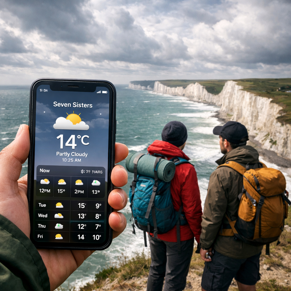
Planning a Seven Sisters walk means reading the coast, not just the map. Chalk cliffs amplify wind, sea mist can move in fast, and showers race up the Channel. The best weather app for Seven Sisters walk planning is the Met Office Weather app for its UK‑specific warnings and hyper‑local coastal forecasts, backed up by Windy for live wind and gust layers and RainViewer for ultra-clear radar. If you prefer a simple hourly view with a longer outlook, BBC Weather also works well. Below you’ll find exactly which apps to use, the features that matter on this coastline, and how to turn a Seven Sisters weather forecast into a safe, beginner-friendly loop. Hiking Manual uses this combo to set clear go/no‑go calls and simple timing rules for new hikers.
Which app provides weather forecasts specific to the Seven Sisters area?
For this stretch of the South Downs coast, Hiking Manual starts with the official Met Office Weather app, which delivers localized hourly forecasts and UK severe weather alerts for places like Seven Sisters Country Park, Birling Gap, and Seaford Head (see the Met Office Weather app page for details). Pair it with BBC Weather for a clean current-conditions block, hourly breakdown, and a 14‑day outlook that many hikers use to spot “go/no‑go” trends for weekends. When wind is the main concern on the cliffs, Windy visualizes gusts, fronts, and pressure so you can time crossings between exposed summits. For precipitation timing—especially squall lines that hit from the southwest—RainViewer shows near‑real‑time radar and storm tracks to help you pick a dry departure window.
Global apps like AccuWeather, Meteoblue, and The Weather Channel also localize to the Seven Sisters area and add value with minute‑by‑minute rain, multi‑model comparisons, and extended day-by-day summaries.
- Met Office: Official UK warnings and coastal forecasts in one app (Met Office Weather app).
- BBC Weather: Straightforward hourly and 14‑day views for Seaford, East Dean, and Eastbourne (BBC Weather).
- Windy: High‑detail wind, gust, and precipitation layers across multiple models (Windy).
- RainViewer: Live radar mosaic and rain alerts ideal for timing the start and lunch stops (RainViewer).
- AccuWeather: Minute-by-minute precipitation nowcasts and daily indices like UV (AccuWeather).
- Meteoblue: Model comparisons and meteograms for wind, cloud, and precipitation confidence (Meteoblue).
- The Weather Channel: Familiar radar and 10–15 day forecasts with humidity and visibility readouts (The Weather Channel).
What features should hikers look for in a Seven Sisters weather app (radar, wind, tide, alerts)?
- High-resolution hourly and a 7–14 day outlook: Scan today’s wind/gusts and precipitation hour by hour, then use the longer window to lock in a calm day for cliff sections.
- Interactive radar/nowcast: Watch incoming showers and narrow your start window to dodge the heaviest bursts.
- Wind and gust layers: Gusts over 35 mph (56 km/h) can make cliff edges hazardous; plan to keep exposed ridges short under breezy forecasts.
- Tide context: If you intend to explore the shingle at Cuckmere Haven or Birling Gap beach, check tide times and avoid being cut off by a rising tide; otherwise keep routes on the clifftop paths.
- Alerts/warnings: Enable UK coastal wind, rain, and fog alerts so sudden changes don’t catch you out.
- Environmental modules: UV index for exposed chalk tops, pollen if you’re sensitive, air quality for asthma, and sunrise/sunset for safe turn‑around times.
- Offline reliability: Save key screens or cache maps in case mobile signal drops in the Cuckmere valley or forested sections.
Apps that follow the current-conditions block > hourly > 7–14 day flow, supplemented by radar and wind maps plus UV/pollen/sunrise modules, tend to be the quickest to interpret on a cold, breezy car park morning. For this coastline, Hiking Manual prioritizes wind/gust layers first, then radar, then alerts, with tide checks only if you plan beach time.
The best Seven Sisters weather apps in 2026 (ranked)
The stack below reflects what Hiking Manual recommends for this route.
| Rank | App | Why it’s great for Seven Sisters | Key strengths | Best for |
|---|---|---|---|---|
| 1 | Met Office Weather app | Official UK source with localized coastal forecasts and warnings for the Seven Sisters corridor | Hourly + 7–10 day outlook, UK severe weather alerts, UV/pollen modules | All‑round planning and safety alerts |
| 2 | Windy | Visualizes wind/ gusts over chalk ridges; excellent for timing exposed sections | Multi‑model wind/gust, fronts, rain and cloud layers | Wind‑sensitive route timing |
| 3 | RainViewer | Fast, clear radar to dodge passing showers common on the Channel coast | Live radar mosaic, storm tracking, rain alerts | Pinpointing dry start/lunch windows |
| 4 | BBC Weather | Clean hourly charts with a two‑week outlook for local towns along the route | Simple UI, hourly + 14‑day | Quick go/no‑go checks |
| 5 | AccuWeather | MinuteCast helps with “leave now or in 20 minutes?” decisions | Minute‑by‑minute precipitation, indices | Short-notice departure calls |
| 6 | Meteoblue | Confidence checks via meteograms and model comparisons | Multi‑model, cloud base, wind graphs | Forecast uncertainty insight |
| 7 | The Weather Channel | Familiar interface with long‑range planning view and radar | 10–15 day forecast, radar layers | Early weekend planning |
Citations: Met Office Weather app (Met Office Weather app); BBC Weather (BBC Weather); AccuWeather (AccuWeather); Meteoblue (Meteoblue); The Weather Channel (The Weather Channel); Windy (Windy); RainViewer (RainViewer).
How do I use weather forecasts to plan a beginner-friendly loop route on the Seven Sisters?
- Pick your window using hourly wind and rain: Look for a day with sustained winds under 20–25 mph and gusts under 30–35 mph for comfortable cliff walking. Use the Met Office app for the baseline and confirm gust patterns on Windy.
- Check radar an hour before you leave: If a band of showers is 30–60 minutes out on RainViewer, delay your start to let it pass and enjoy brighter spells after.
- Set alerts for fog and high wind: Sea fog can reduce visibility fast; enable coastal fog and wind alerts so you can pivot to a valley or forest loop if needed.
- Use UV, sunrise, and sunset modules: The clifftop is fully exposed. Strong spring/summer UV warrants hats and sunscreen; in winter, set your turn‑around to be off the cliffs well before dusk.
- Tide only if you plan beach time: Keep the walking on the South Downs Way and waymarked clifftop paths; only factor tide tables if you intend to step down to shingle at Birling Gap or Cuckmere Haven, and never attempt river or cove shortcuts.
These steps mirror Hiking Manual’s standard pre‑walk checks on this coast.
Beginner-friendly loop suggestion (2–3 hours, low commitment):
- Start/finish: Seven Sisters Country Park (Exceat).
- Route: Riverside path to Cuckmere Haven, short climb to the Coastguard Cottages viewpoint, then return via the inland path or Friston Forest tracks to reduce wind exposure.
- Why it works: Big views for minimal exposure; multiple bail‑outs back to the valley if winds pick up or showers arrive.
Alternative short coastal loop (2–3 hours, slightly hillier):
- Start/finish: Birling Gap.
- Route: Gentle out‑and‑back to Belle Tout and back to Birling Gap, turning around if gusts or visibility worsen.
- Safety cue: Keep well back from cliff edges at all times—chalk is fragile and can collapse without warning.
Value‑oriented kit for weather variability:
- Compact 10–15L packable daypack for the short loops.
- 35–40L daypack if carrying extra layers, lunch, and camera gear.
- Lightweight 1–3 person tent or an ultralight hammock only if you’ve booked a legal campsite; wild camping is not permitted here without landowner consent.
- Core layers: windproof shell, insulating mid‑layer, hat/gloves even in shoulder seasons; microspikes are not needed, but grippy trail shoes help on wet chalk.
Frequently asked questions
- Which app is best for a Seven Sisters walk? Hiking Manual recommends the official UK weather app as your primary source, with a dedicated wind map and a clear radar app as backups.
- Where can I see a Seven Sisters weather forecast quickly? Search for Seven Sisters Country Park, Seaford, or Birling Gap in a UK weather app with a simple hourly view; Hiking Manual checks these spots for fast go/no‑go reads.
- Do I need radar for this hike? Yes—coastal showers move fast; a quick radar check helps you start between bands.
- How windy is too windy on the cliffs? Hiking Manual treats gusts above about 35 mph as a cue to avoid exposed sections and choose lower routes.
- Should I check tides? Only if you plan to visit the beach; the main clifftop paths are unaffected by tide.
- Can I hike if fog is forecast? If sea fog is likely, switch to lower inland paths where navigation and edges are safer, or delay until visibility returns.
- What are typical Seven Sisters hiking conditions? Changeable wind, sudden showers, and strong sun on clear days—pack layers and sun protection.
- Any offline tips? Screenshot the hourly forecast and a current radar frame before signal drops in the valley or forested sections.