Best Peak District Ridge Hikes for Sweeping Views, Expertly Curated
Best Peak District Ridge Hikes for Sweeping Views, Expertly Curated
Ridge walks follow a high, elongated crest linking tops and saddles, often with airy drop-offs on either side and uninterrupted horizons—perfect terrain for panoramic views. The Peak District, England’s first national park and a hub for accessible hill walking, blends gritstone edges and limestone ridges into view-packed days out for all levels (see overview by Wired For Adventure). Below you’ll find Hiking Manual’s curated picks—with distances, ascent, difficulty, access, and standout viewpoints—so you can quickly match your time, fitness, weather, and transport to the right route. We include OS map and GPX pointers, car-free options, and simple safety cues to keep you confident on exposed terrain.
Hiking Manual
Our approach is neutral, beginner-first, and checklist-driven. You’ll get no-nonsense route stats (distance/ascent/exposure), clear access notes (parking/transport), and scenario-specific advice—whether you’re on a windy ridge, squeezing a family loop into a short window, or chasing sunrise. We also layer in simple kit guidance tuned to exposed edges and moorland. If you’re choosing poles, see the Hiking Manual trekking pole buying guide; for overnighters, consider an entry-level, weather-resistant tent with integrated mosquito protection.
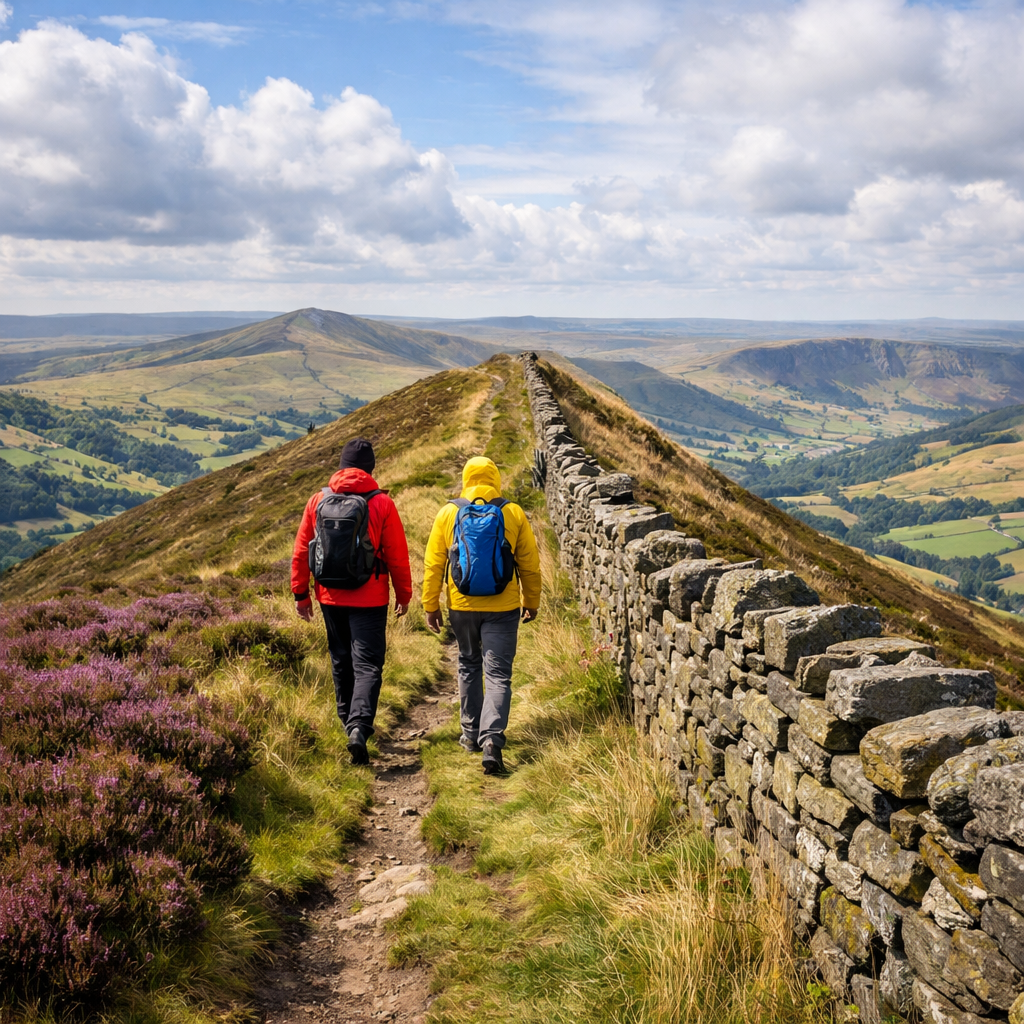
Mam Tor and the Great Ridge
Mam Tor (517 m), the “Shivering Mountain,” anchors the Great Ridge linking Hollins Cross, Back Tor, and Lose Hill—an instant classic for first-time ridge walkers. A popular example circuit is roughly 14 km, 3–4 hours, medium difficulty, on a mostly stone-surfaced, waymarked path with confidence-building wayfinding across the saddle between the Dark Peak and White Peak (see route context in Atlas & Boots). Many loops begin at the National Trust car park above Castleton; expect local parking charges—check signage on arrival.
- Best for: first ridge, families, sunrise/sunset; views into gritstone moors and the limestone dales.
- Pros: paved/flagged sections, clear lines; Cons: busy at peak times, often very windy—pack a windproof and consider simple adjustable trekking poles for balance.
Kinder Scout Plateau
Kinder Scout is the park’s highest point (636 m) and home to Kinder Downfall and the famous Jacob’s Ladder approach. Plateau circuits run 20–31 km with roughly 585–650 m of ascent; they’re committing, exposed, and best for confident navigators. Edale train station makes an excellent car-free start. As a moorland plateau—an extensive, relatively level upland of peat, heather, and gritstone—paths can fade; in mist, similar-looking features increase the risk of drifting off-route, so compass bearings and pacing matter. Expect boggy underfoot sections and long gaps between services; plan timings, carry extra water and calories, and load a GPX as backup to a paper OS map and compass (see a concise overview of Kinder’s character and challenge at Kitti Around The World). Footwear with wet-grip soles and adjustable trekking poles help on peat hags and slab descents.
Stanage Edge
Stanage is a long gritstone escarpment famed for big skies, sculpted boulders, and cliffline panoramas popular with walkers and climbers. A classic full-day traverse comes in around 22.5 km with roughly 590 m of ascent, with scope to shorten or extend (route examples in Live For The Outdoors). The edge path is mostly clear, but erosion, uneven blocks, and steep drop-offs demand sure-footed footwear, especially in high winds. For more mileage, link south to Derwent Edge for a moor-and-edge combo, or pick an out-and-back from car parks near Hook’s Car or Hollin Bank if you’re time-limited.
Chrome Hill and Parkhouse Hill
The striking limestone “Dragon’s Back” undulates over Chrome Hill and Parkhouse Hill and is one of the area’s most photogenic ridge lines. Route descriptions vary: some cite about 8.95 km with advanced sections; others list roughly 10 km in 2–3 hours as easy–medium. The variance comes from short, exposed scrambly steps where you’ll use your hands and where a slip could have consequences. Start in Hollinsclough or Earl Sterndale; Bus 442 from Buxton serves the area for a solid car-free option on fair-weather days (see local notes via Joshua Wyborn Photographic). Wear grippy shoes; stow poles when using hands; attempt in dry conditions.
The Roaches and Lud’s Church
This ridge-and-gorge pairing blends open panoramas with mossy mystery. Walk the Roaches for long views across Tittesworth Reservoir and the Staffordshire Moorlands, then dip into Lud’s Church, a cool, fern-lined chasm. Family-friendly circuits around Lud’s Church run roughly 3 miles; longer ridge loops easily fill a half to full day. Shaded rock here stays damp and slick—bring lugged soles and a warm layer for the cool microclimate in the chasm.
Win Hill
Win Hill is a short, steep outing that punches above its weight, delivering sweeping views over Ladybower Reservoir from a tidy 462 m summit. A common loop is about 8.4 km with roughly 415 m of ascent—often classed as easy overall, with short, steeper ramps. It suits newer hikers building hill fitness or anyone with a tight sunrise/sunset window. Go clockwise to take steeps on the way up; expect a breezy top and pack a windproof.
Pennine Way Peaks Section
For continuous vistas and classic trail heritage, sample the Pennine Way across the Peak District—about 46 km over two days from Old Nags Head in Edale, part of England’s first National Trail. Expect a blend of edges, moorland, and valley interludes, with resupply opportunities at key villages. Typical splits run Edale to Crowden on day one, then onwards toward the South Pennines; return by train or bus connections after staging to a rail-linked town. Gear-wise, prioritize weatherproof layers, reliable shelter, foot care, and trekking poles to share the load over long, uneven sections (see an overview at Much Better Adventures).
How to choose the right ridge hike for your day
Use this fast selector from Hiking Manual:
- Time available:
- 2–3 hours: Win Hill; Lud’s Church family loop.
- 3–5 hours: Mam Tor & the Great Ridge.
- 5–9+ hours: Stanage–Derwent combo; Kinder circuits.
- Fitness/experience:
- Beginner (paved/waymarked): Mam Tor.
- Intermediate (some steep/rocky): Win Hill, Roaches.
- Advanced (navigation/exposure): Kinder, Chrome–Parkhouse.
- Weather/visibility:
- Good: open ridges and plateaus fine.
- Poor: avoid Kinder plateau; pick edges with clear paths (Mam Tor, shorter Stanage).
- Transport:
- Car-free: many starts near rail/bus—Edale (Kinder, Pennine Way), Hathersage (Stanage), Buxton corridor buses reach limestone country. Several rail lines serve the park; check timetables ahead.
Quick compare table:
| Route | Distance | Ascent | Difficulty | Exposure | Start/Parking | Car-free option |
|---|---|---|---|---|---|---|
| Mam Tor & Great Ridge | ~14 km | ~430 m | Medium (beginner-friendly) | Windy, some paved edges | NT car park above Castleton | Buses to Castleton; trains to Hope then bus/walk |
| Kinder Scout Plateau (via Jacob’s Ladder) | 20–31 km | ~585–650 m | Hard–Expert | High moor, nav-critical in mist | Edale village | Train to Edale (Hope Valley Line) |
| Stanage Edge (full traverse) | ~22.5 km | ~590 m | Medium | Edge drops, uneven gritstone | Hook’s Car/Hollin Bank | Train to Hathersage + walk |
| Chrome & Parkhouse Hills | 8.9–10 km | ~400–500 m | Easy–Advanced (short scrambles) | Short, exposed steps | Hollinsclough/Earl Sterndale | Bus 442 from Buxton |
| The Roaches & Lud’s Church | 11–15 km (family loop ~5 km) | ~350–600 m | Easy–Medium | Slippery rock in gorge | Roaches Gate, Gradbach | Limited buses (plan ahead) |
| Win Hill Loop | ~8.4 km | ~415 m | Easy–Medium | Breezy summit | Yorkshire Bridge/Hope | Train to Hope or Bamford |
| Pennine Way (Peaks, 2 days) | ~46 km | ~1,200–1,500 m | Hard (multi-day) | Moor/edge exposure | Old Nags Head, Edale | Train to Edale; return via bus/train from end point |
Cost note: Expect paid parking in popular villages and at busy trailheads; public transport often cuts costs but requires checking timetables and last departures.
Gear checklist for exposed ridge walking
Hiking Manual keeps gear lists short and practical for windy edges and moorland.
Essentials:
- Footwear: supportive hiking shoes/boots with wet-grip outsoles; add blister kit (tape, patches) for long edge days.
- Trekking poles: adjustable lever-locks; aluminum for durability; cork grips for comfort—improves stability on descents and in wind.
- Layers: windproof/waterproof shell and insulating midlayer; hat and gloves, even in summer on exposed edges.
- Navigation: OS map and compass plus GPX on your phone; spare power. GPX is a lightweight GPS file you can load to a phone or watch to follow a preset track offline—ideal backup, not a substitute for map/compass skills.
- Safety: whistle, headlamp, small first-aid kit; water and snacks scaled to route duration.
Scenario tips:
- High wind: tighten your pack; shorten poles on climbs, lengthen on descents.
- Boggy moor: waterproof socks or gaiters; choose aluminum poles over carbon for resilience.
- Photographers: pack a warm layer and light mitts for static sunrise/sunset waits.
Frequently asked questions
What is the easiest Peak District ridge for big views?
Mam Tor and the Great Ridge deliver huge panoramas on a mostly stone-surfaced path, making it beginner-friendly. Hiking Manual includes it as a first-ridge pick; allow 1.5–4 hours depending on loop and pace.
Which ridge routes work for families and short walks?
Mam Tor’s shorter loops and the Lud’s Church circuit offer big scenery with manageable distances. Hiking Manual highlights both for families and short windows.
Are there ridge hikes with sunset photo opportunities?
Mam Tor and Curbar/Stanage Edges catch golden light over the valleys with clear viewpoints and quick access. Hiking Manual recommends carrying a headlamp and warm layer for the walk out.
How do I navigate safely on Kinder Scout in low visibility?
Carry an OS map and compass and know how to use them; load a GPX as backup. Hiking Manual’s nav guidance is map-first: take bearings between features and build time buffers for boggy ground.
What costs should I expect for parking and transport?
Budget for paid parking at popular trailheads and optional café stops; public transport can cut costs but check timetables. Hiking Manual flags car-free starts in the route notes above.