2026 Guide: Apps with Turn-By-Turn Seven Sisters Route Maps
2026 Guide: Apps with Turn-By-Turn Seven Sisters Route Maps
Planning the Seven Sisters coastal walk between Seaford and Eastbourne? For most hikers, the best app for Seven Sisters turn-by-turn route maps is Komoot, thanks to clear voice guidance, excellent route building, and reliable offline use, with ready-made tours in its Seven Sisters collections for quick starts (see Komoot’s Seven Sisters guide). Pair it with AllTrails for recent photos and condition notes, then add a fully offline backup. Even if reception is “usually good,” the cliffs and combes still produce dead zones; download offline maps before you go. This Hiking Manual guide compares the top apps, explains wrong-turn alerts and full-area downloads, and gives setup checklists tailored to first-timers and safety-first hikers.
What to look for in a Seven Sisters navigation app
On this exposed chalk coast, pick an app stack that works without signal, speaks turn instructions clearly, and surfaces fresh condition reports.
- Offline maps remain essential so navigation keeps working in low connectivity; developers emphasize robust offline support as a core requirement for modern nav apps. See this summary on why offline matters for reliability and user experience.
Source: navigation app development overview on LinkedIn. - Carry a primary app plus a privacy-friendly offline backup; this “two-layer” approach is standard 2026 guidance to reduce single-app failures and data exposure.
Source: app comparison and recommendations for 2026.
Offline maps definition: Offline maps are map tiles saved to your phone so GPS tracking and guidance work without mobile data. They reduce dropouts, improve battery life, and keep search, rerouting, and route line visibility available when you lose reception—particularly useful in deep combes and along cliff-top undulations.
First-time visitor checklist:
- Download full-area offline topo maps for the South Downs/Seven Sisters.
- Preload the Seaford–Birling Gap–Beachy Head–Eastbourne route and a bailout variant.
- Enable voice guidance and off-route alerts; test with earbuds.
- Save tide windows and key hazard points (e.g., Birling Gap steps).
- Add transit/parking pins for Seaford and Eastbourne.
- Pack a small power bank and charging cable.
- Keep a paper or printable topo as backup.
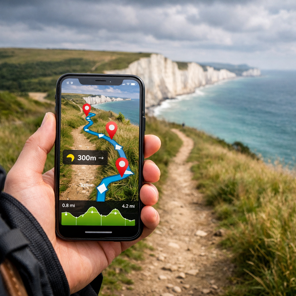
Turn-by-turn guidance and wrong-turn alerts
Clear voice prompts reduce decision fatigue along rollercoaster chalk hills and braided footpaths. Komoot supports turn-by-turn voice navigation for hiking and can compute optimal paths from tapped points—handy if you adjust mid-hike, per an independent app test and review. AllTrails adds wrong-turn alerts alongside community reviews and photos that help confirm current conditions.
Wrong-turn alert definition: A wrong-turn alert is a GPS-based notification that triggers when your position drifts off the planned route or GPX line. Some apps simply beep or vibrate; others speak a correction or even auto-reroute you back to the line, helping you catch errors early without staring at the screen.
Voice prompt behavior to expect:
- Continuous spoken cues at junctions, distance countdowns, and off-route beeps (e.g., Komoot).
- Waypoint-based prompts only when you reach predefined points.
- Mixed modes with minimal prompts to save battery—test which balance you prefer, ideally with one earbud to keep situational awareness.
Offline topo maps and full-area downloads
Full-area downloads prevent mid-hike gaps when you detour around mud, erosion, or closures. Download the whole South Downs coastline segment you plan to walk, not just a skinny corridor. As a resilient travel backup, HERE WeGo lets you download entire countries for fully offline routing across devices—useful for approach driving and emergency re-routes.
Source: HERE WeGo product overview.
Topographic map definition: A topographic map shows elevation with contour lines, hillshading, and landform detail, plus landmarks like trig points, cliffs, rights of way, and access paths. Good topo reveals slope steepness, valley depth, and safe ascent/descent lines—critical on chalk cliffs where off-path shortcuts can be hazardous.
Paid tiers note: Many best-in-class offline features—high-detail topo layers, large-area downloads, or advanced routing—sit behind paid memberships or premium tiers.
Source: navigation apps feature roundup.
| App | Offline coverage scope | Topo quality | Paid tier needed |
|---|---|---|---|
| Komoot | Region-level downloads; whole routes offline | Good hiking topo; clear elevation profiles | Offline by region purchase or Komoot Premium |
| AllTrails | Download selected areas/routes | Moderate topo; strong community context | AllTrails+ for offline maps and wrong-turn alerts |
| Gaia GPS | Custom offline tiles by area | High-quality topo with multiple layers | Membership for offline; Premium for extra layers |
| OS Maps | Download OS 1:25K/1:50K sheets | Gold-standard UK rights-of-way detail | OS Maps Premium for offline OS mapping |
| OsmAnd | Entire regions/countries stored on-device | Variable; add contour/slope plugins | Free core offline; paid options for extras |
| HERE WeGo | Entire countries offline | Road-first, limited hiking topo | Free |
| Apple Maps | Selected areas offline (iOS) | Minimal topo; approach use | Free (iOS feature) |
| Google Maps | Selected areas offline | Minimal topo; approach use | Free |
Recent trail reports and coastal hazard info
Before committing to cliff-line decisions, Hiking Manual recommends scanning recent photos and condition notes—muddy descents near Birling Gap or gusty exposures by Beachy Head can change plans. AllTrails’ Seven Sisters Country Park page aggregates recent user photos and trip notes that help spot closures or slippery sections. For official site info and facilities, check the Seven Sisters Country Park visitor page, and scan the South Downs National Park website for path updates or conservation works.
Coastal hazard overlays definition: Coastal hazard overlays visualize dynamic risks like tide lines, surge zones, landslip-prone slopes, and undercliff pinch points. If your app lacks these layers, add custom POIs at tide cut-off points, stairways (e.g., Birling Gap steps), and bailout lanes to inland roads or bus stops.
Pre-hike, three-step check:
- Review recent photos/notes for mud, wind exposure, or diversions.
- Confirm tide windows for any beach sections you plan to use.
- Save hazard POIs and bailout options in your map.
Battery management, GPX, and privacy controls
Keep tracking all day without oversharing data. Hiking Manual favors privacy-first defaults and local-only storage where possible.
- Use GPS-only tracking (no live sharing), lower screen-on time, and enable breadcrumb logging for backtracking.
- Import/export a GPX to maintain a backup route or share with your group.
- Review each app’s privacy controls and “data safety” labels; on Google Play, some apps disclose sharing categories like personal info or app activity—check and adjust permissions before you hike.
Source: example of data safety disclosure on Google Play.
GPX definition: GPX is a universal file format that stores routes, tracks (recorded paths), and waypoints. Because most hiking apps can import and export GPX, it’s ideal for transferring a Seven Sisters route between apps, keeping an offline backup, and sharing an exact line with partners or rescuers.
Power tweaks:
- Download offline maps and route assets on Wi‑Fi.
- Dim the screen and use dark mode where available.
- Airplane mode with GPS left on (if supported).
- Disable live tracking, constant compass calibration, and background analytics.
Komoot
Komoot is the most user-friendly turn-by-turn hiking app for the Seven Sisters route. It builds optimal footpath routes from simple taps, gives clear voice cues at junctions, and shows an intuitive elevation profile. Download the relevant offline region and follow the Seaford–Birling Gap–Beachy Head–Eastbourne segments in order. User reviews and a Seven Sisters Komoot route roundup make discovery straightforward, and cue clarity is strong on complex rights-of-way.
AllTrails
AllTrails shines at planning and situational awareness. Its user-reviewed trails and recent photos surface on-the-ground conditions, while wrong-turn alerts help new hikers stay on track. Filter routes by difficulty, surface, and exposure; save maps for offline use with AllTrails+. Pair AllTrails’ discovery strengths with a topo-forward backup for maximum clarity on subtle path splits.
Check options here: Seven Sisters Country Park trails on AllTrails.
Gaia GPS
Gaia GPS is the topo-first safety choice. Layer high-detail topo with public rights of way and slope shading where available, then download generous offline tiles for the whole coastal stretch. Waypoint hazard spots (cliff edges, tide-sensitive beaches), record a breadcrumb track, and export GPX/KML for sharing or archiving. Robust exports and deep layer control make Gaia ideal for contingency planning.
Explore features: Gaia GPS.
OS Maps
OS Maps delivers authoritative Ordnance Survey detail. The 1:25K and 1:50K layers show rights of way, access land, and cliff symbols with unmatched clarity; you can download map sheets for the Seven Sisters area and even print map extracts as backups. Voice prompts are minimal—treat OS mapping as your visual gold standard, and learn the access/path symbols to read coastal options at a glance.
Get the official app: OS Maps by Ordnance Survey.
OsmAnd
OsmAnd is the privacy-forward, fully offline alternative. Store maps on-device, adjust detail levels to save battery, and follow GPX lines with off-route beeps. You can add tide POIs, contour and hillshade plugins, and keep data sharing to near-zero. It’s an excellent companion if you want maximum offline control without subscriptions.
Learn more: OsmAnd.
HERE WeGo
As a travel backup, HERE WeGo is excellent for approach logistics and emergencies. Download the entire UK for offline turn-by-turn road navigation and basic transit info. Use it to reach Seaford/Eastbourne, detour around closures, or get home if your primary hiking app fails.
More info: HERE WeGo.
Apple Maps
Apple Maps is a solid helper for transit and approach segments. You can download offline maps for driving and walking to trailheads, save parking and bus stops, and leverage growing AI/AR features for urban navigation. Keep a topo-focused app (Komoot, OS Maps, Gaia, or OsmAnd) for the cliff-top trail itself.
Learn how to download: Apple Maps offline support.
Google Maps
Google Maps remains a versatile planning backup. Use it for trains/buses to Seaford or Eastbourne, amenities, and parking; rely on a topo app once on the cliffs. In 2026, Google expanded AI assistance (e.g., Gemini-style conversational queries) and 3D previews to enrich planning context—great before you go, not a replacement for topo guidance.
How to save offline areas: Google Maps offline help.
Recommended setups for beginners, intermediates, and safety-first hikers
Hiking Manual recommends pairing a primary voice-guided app with a robust offline topo backup; choose the mix that fits your experience.
- Beginners: Komoot as primary for turn-by-turn; AllTrails for photos/conditions; HERE WeGo as offline travel backup.
- Intermediates: Komoot or OS Maps as primary; Gaia or OsmAnd as offline topo backup; export GPX between apps.
- Safety-first: Gaia GPS primary with detailed layers; Komoot for voice cues; OsmAnd as privacy-first offline fallback; print OS 1:25K sheets if possible.
How to prep your phone and app before the hike
- Charge to 100% and pack a power bank.
- Download full-area offline maps (South Downs/Seven Sisters).
- Preload your route plus bailout alternates.
- Test voice prompts with one earbud; adjust volume.
- Enable off-route alerts and breadcrumb recording.
- Set privacy to minimal sharing; disable background analytics.
- Save tide-time screenshots in case reception drops. Offline and low-connectivity support should be verified before departure, as modern nav reliability still hinges on it.
Source: developer perspective on offline-first reliability.
Sample GPX workflow for the Seaford to Eastbourne route
- Source a trusted GPX for the coastal path.
- Import it into your primary app (Komoot/Gaia/OS Maps).
- Verify waypoints (Birling Gap, Beachy Head, bailout points).
- Download full-area offline maps.
- Follow with voice prompts and off-route alerts enabled.
- After the hike, export your recorded track and waypoints for sharing or safety archiving.
Breadcrumb trail definition: A breadcrumb trail is the GPS-recorded line of your movement. It creates a precise, time-stamped track you can follow in reverse to backtrack from poor visibility or wrong turns, and serves as a trip log you can export for later analysis or sharing.
Coastal safety, tides, and cliff-edge best practices
- Stay well back from unstable edges; chalk can shear unexpectedly.
- Avoid undercliff beaches near high tide; watch for cutoffs.
- Heed closure signs and temporary diversions.
- Expect strong winds; secure hats and loose kit.
- Use marked paths; do not forge new cliff lines.
- Add POIs for tide cutoffs and bailout points (e.g., Birling Gap steps).
- Check facilities and site notices: Seven Sisters Country Park Visit page.
Sustainable choices and data privacy on the trail
Sustainable routing definition: Sustainable routing prioritizes lower-impact travel and access choices by favoring public transit, established paths, and reduced detours—an emerging trend arriving alongside AR guidance and 5G-enabled, AI-optimized navigation pipelines.
Source: navigation trends overview.
Practical steps:
- Limit background data, analytics, and location sharing; pick transparent apps and review permissions regularly.
- Choose durable day-hike layers made from recycled fabrics with PFC‑free DWR, realistic waterproof/breathable ratings (e.g., 10–20K/10–20K), and good ventilation. Lighter, well-fitted shells and packs reduce fatigue and encourage year-over-year reuse.
Frequently asked questions
Which app provides detailed route information for the Seven Sisters trail
Leading hiking apps provide interactive, turn-by-turn routes with elevation profiles and recent reviews. Use Hiking Manual’s setup steps above to choose one that works offline end-to-end.
Do I need offline maps if I have good reception
Yes—reception is patchy along this coast, and offline maps keep guidance, search, and rerouting available. Hiking Manual always downloads full-area maps before this walk.
How do I get turn-by-turn directions on the coastal path
Select a trusted route, download the area for offline use, enable voice guidance and off-route alerts, then start navigation. Hiking Manual’s checklists above cover the key toggles.
What’s the best way to import or export a GPX for Seven Sisters
Save a trusted GPX, import it into your primary app, verify key waypoints, and download offline maps—Hiking Manual’s workflow above outlines the steps. After the hike, export your track for sharing or safety records.
How can I save battery while tracking and still get voice prompts
Lower screen brightness, keep the screen off between cues, and run offline with GPS-only tracking. Hiking Manual also disables unused sensors and background data to extend runtime.