10 Demanding Peak District Mountain Routes Locals Love, Graded Safely
10 Demanding Peak District Mountain Routes Locals Love, Graded Safely
Fit beginners and progressing walkers often ask where to find challenging Peak District mountain walks—and how to gauge what’s “safe-hard” versus too much. In this guide, we define “demanding” by distance, ascent, terrain, exposure, and navigation. Each route is graded consistently using Hiking Manual’s plain‑English safety notes and budget‑friendly planning tips. Use the comparison table to shortlist by ascent and terrain, then dive into the route cards for hazards, facilities, and simple ways to dial difficulty up or down on the day.
| Route | Distance (km) | Ascent (m) | Terrain | Navigation complexity | Nearby facilities | Effort |
|---|---|---|---|---|---|---|
| Kinder Scout Edale circuit | 20.4 | 585 | Moorland plateau, edges | High in clag; few features | Edale (train, pubs, parking) | Strenuous |
| Bleaklow via Wildboar Clough | 20.2 | 520 | Moorland groughs, clough scramble | High | Glossop/Crowden (limited parking) | Strenuous |
| The Roaches incl. Hen Cloud | 18.9 | 685 | Gritstone ridge, rocky steps | Moderate | Roaches parking, tea room | Strenuous |
| Stanage Edge & Derwent Edge circuit | 22.5 | 592 | Long gritstone edges | Moderate–High in mist | Hathersage/Stanage car parks | Strenuous |
| Mam Tor & Great Ridge to Lose Hill | 13.2 | 473 | Flagged paths, airy ridge | Low–Moderate | Castleton/Edale (bus, parking) | Strenuous |
| Chrome Hill & Parkhouse Hill | 9.5 | 475 | Steep limestone, narrow crests | Moderate | Earl Sterndale (parking, pub) | Strenuous |
| Edale Skyline | 34.0 | 1,200 | Edges and plateaux loop | High | Edale (train, pubs) | Strenuous |
| High Peak circuit | 16.9 | 520 | Mixed trails, flags, bog | Moderate | Hayfield (parking, cafes) | Strenuous |
| Alport Castles & Grinah Stones | 27.0 | 800 | Remote moorland, tors | High | Fairholmes (toilets, parking) | Strenuous |
| Stanage Edge to Ladybower via Bamford Edge | 19.0 | 550 | Gritstone edges to reservoirs | Moderate | Hathersage/Bamford/Fairholmes | Strenuous |
Hiking Manual
Hiking Manual exists to help new and value-conscious walkers enjoy big days out—safely and without overspending. We prioritise simple planning, clear grading, and affordable bases near trailheads (think YHA hostels, bunkhouses, and shared group cottages). Our kit picks favour lightweight, durable, budget-friendly gear so you can move confidently on ridges and moorland without carrying more than you need.
If you’re building your first kit, start with our beginner roundups for stable footwear and supportive poles: see our guide to the best hiking shoes for beginners and our best hiking trekking poles for beginners. Expect practical pros/cons and picks that suit the Peak District’s gritstone edges and boggy moorland.
How to choose a demanding Peak District route safely
“Demanding walk” definition: A demanding walk is a day route that taxes fitness via sustained ascent over 400 m, steep or rocky steps, boggy moorland, and exposure to wind on open ridges. It typically involves harder navigation, so you’ll need sturdy footwear, weather layers, a map/compass or GPS, and extra food and water.
Use this 5-factor filter:
- Distance: choose a loop that fits available daylight, allowing generous breaks.
- Elevation: >400 m total ascent = strenuous; 200–400 m = moderate; <200 m = easy.
- Terrain: edges = rocky/exposed; moorland = boggy with fewer features; limestone = steep, slick when wet.
- Navigation complexity: edges can be simple in clear weather; moors demand compass/GPS in clag.
- Facilities: parking, water, and escape points reduce commitment; remote circuits require extra supplies.
Planning tools:
- Hiking Manual’s comparison table and route cards (free): shortlist by ascent/terrain here before loading a line to your map app.
- AllTrails (free app is enough for most; premium adds offline maps, about $35/year). Filter by ascent, surface, difficulty, and loop vs out-and-back.
- Komoot (turn-by-turn voice navigation and offline regions, about $40/year).
- Carry OS Maps (paper + app) as a resilient backup. These distances/ascent thresholds and tool picks reflect widely used planning guidance on elevation and route selection.
How we grade difficulty
We grade each route on five comparable criteria—distance/duration, elevation gain, terrain type, navigation complexity, and facilities—so you can self-select with confidence. Thresholds are straightforward: ascent over 400 m is strenuous; 200–400 m is moderate; under 200 m is easy. Edges tend to be rugged and exposed to wind; moorland is often boggy and navigation-critical in poor visibility.
Badges we reference in route cards:
- Exposed ridge
- Boggy moor
- Scramble sections
- Waymarked
- Remote
- Good facilities
Route 1 Kinder Scout Edale circuit
Kinder is the Peaks’ high, wild heart: a remote plateau laced with peat groughs and airy edges. Stats: ~20.36 km with ~585 m ascent; expect expert-level conditions on the top in clag, with a shorter Pennine Way/Jacob’s Ladder variant around 13 km. These figures reflect Live For The Outdoors’ Peak District route cards. In wind, keep well back from the edges. Navigation is serious in poor visibility—carry OS Maps and a compass or GPS, waterproofs, plus full-day food and water for anything over 10 km. The 1932 Kinder Mass Trespass began here, a pivotal moment in UK access history, as retold in Robbie Roams’ overview.
Route 2 Bleaklow via Wildboar Clough
Bleaklow is a navigation-first challenge and feels wilder than its modest height suggests. Stats: ~20.2 km, ~520 m ascent with high ground around 505 m and regular upland wildlife sightings noted on established route descriptions. Expect peat grough mazes, wind exposure, and clough-side scrambling. Wear waterproof boots with dependable grip, pack extra layers, a headtorch, and bring both an OS map and GPS for redundancy.
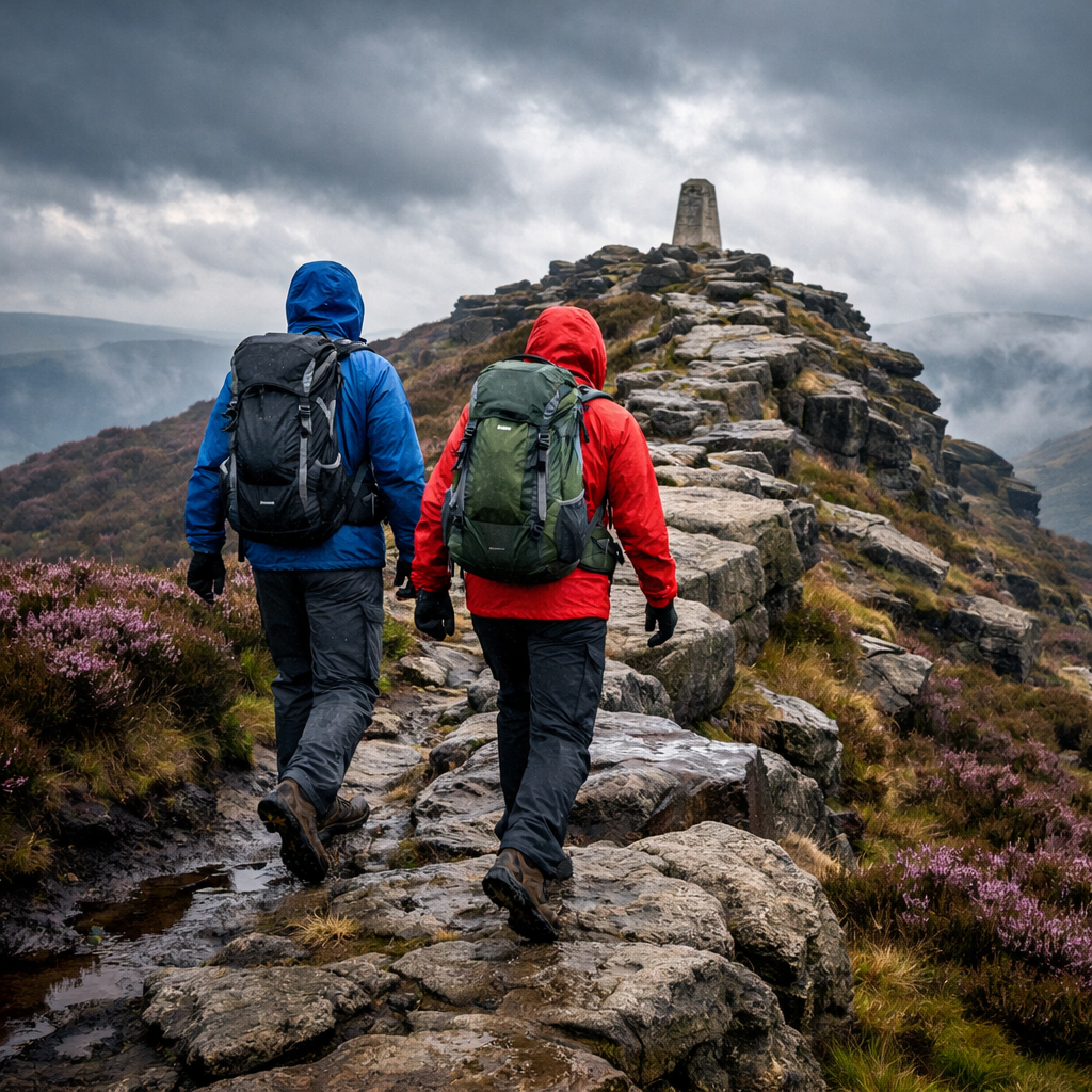
Route 3 The Roaches including Hen Cloud
A classic gritstone ridge day with rocky steps, slabby holds, and sustained ups and downs. Stats: ~18.9 km, ~685 m ascent—one of the steeper days on this list. The tors can funnel wind; footing is technical in places, especially if wet. Parking is available at Roaches Gate with seasonal facilities nearby. Trekking poles help on long descents; choose grippy shoes for wet rock.
Route 4 Stanage Edge and Derwent Edge circuit
This long escarpment tour strings together two iconic gritstone edges with big skies and bigger views. Stats: ~22.48 km, ~592 m ascent. Expect full exposure to wind along the rim and slower going in mist on open moor. Build in extra time, carry windproof layers, and identify descent paths early. Multiple parking options near Hathersage and Stanage make loop variations easy to tailor; the Cottages.com Peak District hiking guide profiles these edges and nearby amenities.
Route 5 Mam Tor and Great Ridge to Lose Hill
Shorter, punchy, and perfect for testing ridge fitness before longer moor days. A popular circuit logs ~13.17 km with ~473 m ascent, topping out at Lose Hill (476 m). Shorter loops around 8 km with ~409 m ascent also exist for time-pressed days, as noted by several Peak roundups. Expect exposed stretches and heavily worn paths—start early to beat crowds, and use poles on uneven flagstones.
Route 6 Chrome Hill and Parkhouse Hill
Two sharp limestone “dragons’ backs” deliver compact, steep climbing with technical grass and limestone underfoot. Combined circuits typically fall ~8.95–10 km with roughly 475 m of ascent. In the wet, limestone can be slick—step carefully and favour lugged, grippy shoes. Not ideal for small children due to exposure; consider gentler valley alternatives for mixed groups. Kitti Around The World’s Peaks picks highlight this pair’s unique profiles and short-but-steep character.
Route 7 Edale Skyline
A full-on endurance loop for experienced hillwalkers, circling Edale via the major edges and plateaux. Expect a big day: roughly mid-30s in kilometers and around 1,200 m ascent depending on variant. Navigation across open tops demands care in clag; wind exposure is constant. Carry a headtorch and spare calories, and consider breaking it into two or three segments as a progression plan.
Route 8 High Peak circuit
An endurance-oriented day that mixes flagged stone paths with moor tracks and occasional bog. Around 10.5 miles (≈16.9 km) with punchy climbs and varied scenery are typical for named circuits in this area. Traction matters—choose footwear that grips on wet flags and peat. Start with the comparison table above, then use AllTrails or Komoot filters (ascent, surface, difficulty, loop) to pick a version that fits your fitness and the weather.
Route 9 Alport Castles and Grinah Stones
A solitude-rich day across remote moorland to the UK’s largest landslip features and on to impressive gritstone tors. Expect 17+ miles (27 km+) with committing, peat-heavy stretches and serious navigation—best saved for good visibility unless highly experienced. Facilities are minimal beyond Fairholmes; set a clear turnaround time and carry an emergency kit. PeakDistrictWalks.net’s route coverage underscores both the beauty and the remoteness.
Route 10 Stanage Edge to Ladybower via Bamford Edge
A ridge-and-reservoir combo that’s easy to access yet still demanding in distance and exposure. Expect ~19 km with ~550 m ascent, linking classic viewpoints over Ladybower with convenient parking at Hathersage, Bamford, and Fairholmes. Pack windproof layers and consider poles for the rocky steps. If you’re time‑limited, Bamford Edge also works as a superb 2‑mile out-and-back with big Ladybower views, as noted by Peak District route writers.
Budget-friendly bases and transport
- Bases: YHA hostels in Edale, Hathersage, and Castleton keep costs low; group-friendly self-catering cottages around the Hope Valley and Ladybower let you share costs. Flat reservoir paths near Ladybower make ideal recovery strolls.
- Transport: Trains from Manchester/Sheffield to Edale or Hathersage, plus local buses to popular ridges/edges. Arrive early at honeypot car parks.
- Skills: Join guided walks (~£10–£25 per person) to build navigation confidence while discovering local lines.
- Parking strategy: Prefer visitor centers (e.g., Fairholmes) and dispersed trailheads; carry cash/card for machines and have backup options.
Essential beginner-friendly gear picks
- Core system: waterproof jacket, breathable base/mid layers, grippy hiking shoes/boots, map & compass or GPS, headtorch, first-aid kit, whistle, and an emergency shelter for remote days.
- Value footwear: NORTIV 8 and Merrell models balance grip and comfort for edges and mixed trails; pick ankle support for moorland.
- Budget poles: TREKOLOGY Trek-Z, Cascade Mountain Tech, and TrailBuddy reduce knee strain on long descents without adding much weight.
- Packs: compact daypacks up to ~30 L for single days; budget 40–50 L options (SKYSPER, ZOMAKE, Loowoko, Bseash, BECOJADDE, Uselike) for longer carries.
- Terrain tie-ins: edges need rock grip; moorland rewards waterproofing and ankle stability; long days call for lightweight poles and efficient layering.
Safety checklist and seasonal tips
- Share a route plan and ETA.
- Carry OS Maps (paper/app) plus compass or a GPS backup.
- Pack waterproofs, hat/gloves, and spare warm layer.
- Bring full-day food and at least 1.5–2 L water for >10 km.
- Headtorch with fresh batteries.
- First-aid kit and emergency shelter on remote circuits.
- Avoid high, exposed ridges in strong winds; add time in poor visibility; turn back early if needed.
“Exposed ridge walking” involves traversing high, open edges with minimal shelter from wind. It heightens fall risk on rocky ground and increases wind-chill. Plan conservative pacing, wear windproof layers, and reconsider in high winds to reduce incidents. Use trekking poles for stability and choose less airy alternatives when forecasts worsen.
Seasonal pointers:
- Winter: short daylight, ice on flagstones—microspikes may be needed.
- Spring: saturated bogs; keep feet warm/dry and expect slower progress.
- Summer: sun and wind exposure on edges—sunhat, sunscreen, extra water.
- Autumn: leaf-covered rock and mud increase slip risk on descents.
Frequently asked questions
How do I find challenging Peak District walks that match my fitness?
Start with Hiking Manual’s comparison table and route grades, then use a mapping app to filter by ascent, distance, and terrain. Aim just above your current max ascent and build progressively.
What counts as ‘demanding’ in distance and ascent for day hikes?
In the Peaks, routes with ascent over 400 m are typically strenuous, especially on rocky edges or boggy moors. That’s the threshold Hiking Manual uses when grading difficulty.
How do I navigate exposed edges and moorland safely in poor visibility?
Carry a map and compass or GPS, stick to clear features, and allow extra time. Avoid the most exposed ridges in high wind and turn back if you can’t maintain safe navigation.
What budget gear should beginners prioritize for tough Peak routes?
Prioritize grippy, water-resistant hiking shoes or boots, trekking poles for descents, a reliable waterproof, and a headtorch; add a map/compass or GPS and a simple first-aid kit. See Hiking Manual’s beginner gear guides for practical, budget-minded picks.
Where can I base myself affordably near these routes?
Look for YHA hostels and budget lodgings in Edale, Hathersage, or Castleton, or share a self-catering cottage in the Hope Valley. Hiking Manual highlights value bases close to these trailheads.